It ends! This section covers the rest of Southland to the finish at Bluff.
Day 60: Te Anau to Aparima Hut
25km, +800m -600m, 7.5 hours
We walked a couple of km to the edge of town to try and get a hitch, avoiding the traffic heading in the wrong direction to Milford Sound. Traffic in our direction was light, and it took about an hour until a young couple from Hong Kong pulled over and we piled in the back.
We picked up the trail from the road, and it was a quick 6km on a flat gravel road to Lower Princhester Hut. There we found Laura and Charlotte about to head back to Te Anau to go to Milford Sound, having spent a cheap rest day in the hut. Princhester Hut was also home to the most disgusting toilet found so far on the trail. The huts all have Nordski long drop toilets which are great, but in varying levels of cleanliness. The huts closest to roads are always the worst.
We cut our break short due to the sandflies, and headed into the forest. It was a decent climb and I was sweating instantly, and enjoying the muddy obstacle course that passes for a trail on the TA. Eventually I tired of the sidling and the scratchy ferns, and on the small downs when it turned into a mud chute I must have fallen on my arse at least three times. We all swore at the trail at various points. It was quite a change in pace from the fast km we’d been able to walk the last few days.
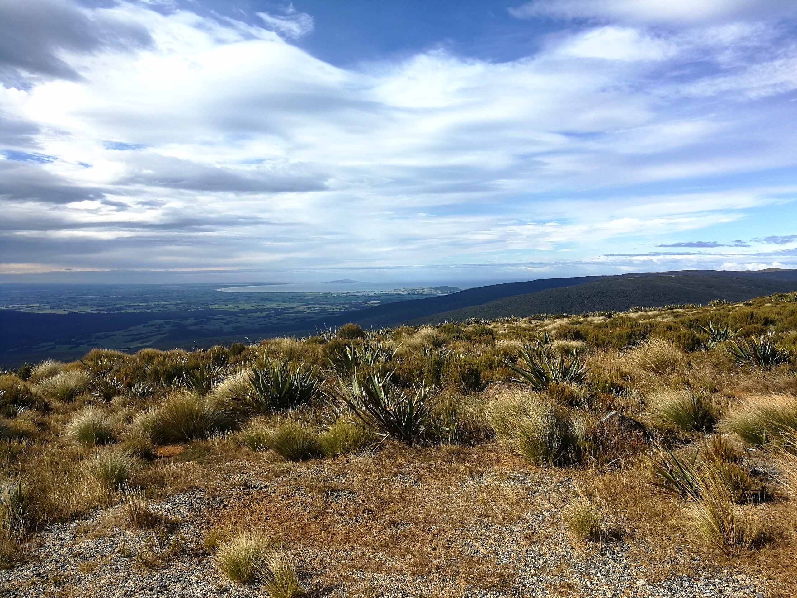
The path improved later on (read: less sidling) and we stopped for lunch at the edge of the forest before entering the tussocks.
The rest of the day was alternating between forest sections, which were windy but had a clear path and weren’t too muddy, and swamp tussock plains, where there was a trail but it was obscured by the long grass. I walked blithely through until I almost fell in a hole covered by the grass, so from then it was slower going as I parted the tussocks with my poles. Sometimes the trail was just bog.

Someone seemed to have come through this stretch with an abundance of DOC orange triangles, and slapped five at each entrance into the forest. It contrasted with the tussock fields where often the poles were hidden by the grass.
A bird of prey that I didn’t recognise (mostly we saw NZ falcons) took an objection to me and flew around screeching for a while before dive bombing at me a few times. I fended it off with my poles (another use!) and hurried back into the windy forest – not something I’d thought I’d say.
I arrived to an empty Aparima Hut, and took about 10 minutes to scrub all the mud off my legs. This was testament to the amount of mud ingrained in my skin, and the sandflies around the water tank meant I had to do a little dance in the mean time.
Ali and Liv arrived later, and I took it personally when the bird hadn’t dive bombed them. No one else came to the 8 bed hut and it was nice to have it to ourselves. We were in bed by 8pm.
Day 61: Aparima Hut to Lower Wairaki Hut
14km, +500m -400m, 4 hours
Slept for 10 hours. It was amazing. I had to face away from the window though as the crescent moon was so bright.
A swing bridge just south of the hut took us over a river that was lower than a lot of rivers we’d had to ford, but I wasn’t complaining. I soon got wet feet anyway in the marshy scrubland.
After half an hour of the manuka flats it was into the forest for the rest of the day. There was a clear path but it was up and down constantly with a decent amount of mud, which made it pretty tiring.
The times and distances on the DOC signs were wildly inconsistent and way too generous, which didn’t help with planning. At one point the time decreased by 2 hours after 500m of walking. After a lower-than knee deep river crossing I made it to the 4 bed Lower Wairaki hut in 4 hours. There I met Catriona from Australia just as she was leaving, who we’d seen in the hut books ahead of us.

The girls arrived and we had lunch in the hut, but couldn’t decide whether to stay there for the night or push on to Telford campsite. I’d got the forecast from my garmin inreach in the morning and it was for rain all night and potentially tomorrow too, so we weren’t keen to camp in a field of sandflies with no shelter in the rain when we could stay in a hut. But if we stayed it would mean a very big day tomorrow with a big climb up and over to Telford campsite and then all through Mt Linton Station.
In the end we decided to stay, and Ali got the fire going. This was potentially our last proper DOC hut too, so we enjoyed lounging in it all afternoon one last time. It was very hard not to eat all my nutella.
Day 62: Lower Wairaki Hut to Birchwood Station
36km, +1100m -1400m, 9.5 hours
We’d set ourselves up for a long day, and as Mt Linton Station has strict rules for TA hikers going through their land, and there had been some issues of the farmer handing out trespass notices to wayward hikers, we wanted to make sure we had plenty of time. So we got up at 6, and headed into the forest by 7 with our head torches as it was still pitch black.
We stuck together and it was quite fun walking in the dark, and the rain had stopped. Gradually it got lighter and we could see the bright oranges of sunrise through the dense trees. Our jumpers came off the same time as we got rid of head torches, as it was a steady climb up. It got steeper near the top and I thought the forest would never end.
I came out of the trees and exclaimed at the view to the south. We were on the highest land between us and the sea, and although it was too hazy to see the sea, it felt within reach for the first time. The girls stayed for a bit as I started descending the windy ridge line.

When I got down to the ‘campsite’ and the boundary of Mt Linton Station I had a quick flapjack break, read all the rules on the sign, then climbed over the style. An easy river crossing led to a 4WD track which climbed steeply up a sizeable hill, and then straight back down the other side. And up again, and down again, keeping a keen eye on the orange markers for fear of being accused of trespassing.
I was getting hungry but wanted to make more of a dent in the day’s distance before lunch, so also made quite a dent in my stash of sweets. The path came down from a balcony to the river which I was going to have to cross, but had lunch first. I still took my shoes and socks off to air out my feet. The girls came as I was finishing, and I waded across the river. It took about 10 minutes of quick walking for the feeling to return to my feet.
The track climbed up to a very large turnip field. The orange poles stuck to the steep fence line, where there was no path. Mollie and Tim, Americans we’d met a few times, were picking their way up the steep slope next to the electric fence. I dared to take the perfectly decent 4WD path 30m away. I couldn’t believe the farmer would rather we trample their crops.
Rain joined the wind every now and again, and I marched along the winding contouring track through the turnip field. It dipped down to a road before climbing back up the other side. I cut the corner off and sank into bog with thick, oozing mud that the next river crossing didn’t wash off.
It was a long day but I felt good; some days my body seemed to work with me and some days against me, with little rhyme or reason. I overtook Catriona later in the afternoon and eventually came out the other side of Mt Linton Station.
It was 2km off-trail along the road to Birchwood Station, which has a cute cabin in their farm for TA walkers. It had electricity, showers and hot running water. It was heaven.
Today took my running total over 1000km (a few days later than the girls due to the section between the big rivers that I missed) and I mused over the power of the human body for a while.
Day 63: Birchwood Station to Merriview hut
26km, +600m -600m, 6.5 hours
A shriek came from the kitchen as I was getting dressed. Liv hadn’t hung her breakfast food bag up last night and a mouse had eaten through her dry bag and into her oats. I had spare so gave her some of my mouse-free ones.
It was a beautiful sunny morning but cold – I was wearing sunglasses, a jumper, gloves and my buff. Gratefully we cut through the farm to get back to the trail, passing a eucalyptus plantation which smelled great.
A steep, grassy jeep track made my calves feel like bursting, but the views from the top were incredible. I could just about see the sea to the south and the spiky Takitimus to the north. The sea!

It was easy, mostly flat, walking along forestry tracks on the top before entering a beech forest path down the other side. It turned into pine forest at the bottom, and I stopped for lunch in the sun before entering the cabbage fields, filled with white butterflies.
A corridor between fields led to the road but also had sheep in – they’d run ahead and then at the last minute race down the side to get behind. With the Americans ahead and the girls behind, the sheep got quite a workout.
The rest of the day was either on roads or forestry track through pine forest, and whilst it was another fairly big distance day the walking was easy. An enterprising couple on Merriview Road built a cute hut for TA walkers at the end of a field, with an honesty box of snacks and some basic goods, as well as fresh eggs from their hens. I wolfed down a bag of Mars bites and a big packet of crisps.
The Americans and Catriona went on to camp further up the trail, so we had the 5 bed hut to ourselves. There was a note in the hut saying to text them for a cold drink, so the owner came over later with beers for us, and muesli for Liv.
Day 64: Merriview hut to Martin’s hut
29km, +1100m -800m, 8 hours
It was a nice and warm morning, but the forecast was for two days of bad rain and wind later, which wasn’t what we wanted heading into the last big obstacle between us and the sea – Longwood forest. Longwood was notorious for it’s man-eating quantities of mud, and we weren’t looking forward to being in the trees with high winds again.
It was an easy gravel road walk to the edge of the woods, and then a forestry track climbed steadily through a eucalyptus plantation. Halfway up the forestry track ended and it was time to enter the woods proper, with a warning sign about abandoned mine shafts away from the trail.
The mud wasn’t too bad in this section, and the ancient forest was silent. The trees were so dense and covered in hanging moss and lichen. I expected elves to come out at any moment. In a break in the trees the ground turned to swamp – at one point my pole sunk to the handle and still hadn’t found solid ground – that’s over my hip height. I found an alternate route. I heard faint shrieks behind me a while later as Ali and Liv came to similar findings.

The trees gave way to marshy scrub and the views of the sea from the top of Bald Hill were incredible. There was an awful lot of forest left between us and the sea that we had to get through though. The peak at the end looked so far away. We had lunch after descending to a quarry before heading back into the forest. It was the last real climb on the TA and I really couldn’t be bothered.
It was only 300m over 2km so wasn’t too bad, it was the following incredibly muddy traverse along the broad forest ridge that got tedious. It was very slow going. There was very little solid ground for 4km, each step sinking to various degrees into bog or mud.
The path firmed up when I reached the final bald peak and I could see the rain showers across the bay. I passed the trig point and descended quickly down back into the trees as the rain started. It wasn’t that far from the treeline to the hut, but it took some careful attention not to just slide in the mud all the way down.
Martin’s Hut was built in 1905 and has ‘character’. The trail notes said it would provide welcome shelter from inclement weather, which was rather ominous, but it wasn’t too bad. It had some floorboards (with sizeable holes to see the mice below), a fireplace, a tiny window and a door that you couldn’t open from the outside. But the weather was inclement, so we were grateful.
The Americans and Catriona pushed on to camp further down the trail, and I went on a little adventure to get water. I considered leaving a note for the girls. There was a very faint trail through dense forest and without the orange markers I soon felt very disconnected. The notes had said there was a river 700m away which felt like a long time and I kept going until I heard water. I took a while scrubbing myself until I was acceptably clean (this is different to actually clean), filled up my Cnoc water bag and tried to bash my way back to the hut without getting too muddy again.
The girls arrived later and we tried to get a fire going but the wood was too damp so we gave up after a while. We were tired and got into bed by 7.30, which I think was a new record.
Day 65: Martin’s hut to Colac Bay
30km, +150m -400m, 6 hours
We were getting out of the forest today! I’d had a restless night and was keen to get moving from the cold and dark hut. Ali found a mouse poo in her mug (which had been inside their jetboil).
It had rained a lot in the night, and we were incredibly glad we’d got through the section of bog and mud yesterday when it hadn’t rained for a while. The wind was getting up and it was forecast for gales today. We decided to detour around the last long section of the Longwood forest water race trail, and follow the forestry road out of the woods which the trail reached after a couple more km of mud.

We were very glad to be out of the woods and back on solid ground. It did make the day’s distance a bit longer though, and meant 20km on gravel roads with heavy showers of rain and hail along with the gales blowing us about. It was a headwind most of the way and sometimes it would stop me in my tracks.
Only slightly looking like I’d been dragged through many hedges backwards, I staggered through the door of the Colac Bay Tavern mid afternoon. I checked in to our room at the bar, which was already populated with a few locals.
“Have you ever wondered if you’re slightly crazy doing this?”
“Most days,” I confirmed.
Post shower we went back to the tavern and I devoured a bowl of wedges with cheese and bacon, as Mollie and Tim tucked into burgers. Jo had popped over from Invercargill to say hi, and we were glad to hear her wrist was sprained not broken, so she was going to continue with the trail from Te Anau next week.
We stayed in the pub for the rest of the day and my hunger continued as I put away a large burger and fries followed by approximately a litre of ice cream and strawberry sauce. I was uncomfortably full afterwards and had only myself to blame.
Day 66: Colac Bay to Riverton
13km, +200m -200m, 4 hours
The forests had accelerated the decline of my shoes, which now had rather sizable holes in the front mesh. I tried duct taping across them but it didn’t stick for long. The sunrise was fabulously pink, and we strolled down the road to the sea. Finally, I had reached the sea.
It was a cold morning but thankfully the wind had dropped to a light breeze. We walked along the washed out coastal road watching the early morning surfers catching waves. The road ran out and it was onto the beach, hard going in the dunes and the soft sand, but beautiful. Our bags were wonderfully light as were carrying very little food, having planned to resupply for the last 2 days in Riverton, and to get there for lunch.
The stretches of soft sand weren’t too long and we were soon into fields on a coastal path climbing up and down the small cliffs, reminding me of the end of the South Downs Way.
We sat for over half an hour staring at the waves crashing on the shore, the sun warming our backs.

A small but effort-requiring climb that we’d been ignoring in our planning led up the fields and then up a manicured path in jungle-like trees that was reminiscent of the Queen Charlotte Track.
From the top we looked down on Riverton and the long sweeping curve of tomorrow’s beach walk. It was a road walk down into town and we found a cafe for lunch – waffles, thick milkshake followed by curly fries.
After checking into our hostel we did our last food shop – carrying luxuries of fresh fruit, bread and hummus. It took far longer than normal as we had too much choice; it wasn’t the default salami, cheese and nutella that I’d become accustomed to for the past 2 months.
Day 67: Riverton to Invercargill
36km, +50m -50m, 8 hours
Another stunning sunrise. Today was going to be a long day and we were on the beach by 8 to make the most of the low tide times and the nice and hard sand which made for quick and easy walking.
We chatted about the hard times on the trail, laughing about how difficult we’d found the Queen Charlotte Track, and reflecting on the Richmonds when I didn’t think I was going to make it any further on the trail.
The clouds cleared and the sunglasses came out, turning into a hot and gorgeous day for a (22km) walk on the beach.

A horse and rider cantered passed when we stopped for a break, and she came over for a chat on her return leg. Dirt bikes careered around the dunes, imitating Burt Munro on the hard sand.
Eventually the glistening of cars on the beach in the distance got closer and we turned onto the road. The trail went almost directly passed a university friend of Ali’s so we popped in for a break and a cup of tea which helped rejuvenate us for the final road walk to Invercargill. We were knackered.
Post shower we went to get drinks to carry for tomorrow’s finale. Invercargill has very strict alcohol laws and supermarkets can’t sell it. There was a liquor store nearby but the cashier thought I looked under 25 – I was flattered until they wouldn’t accept my foreign driving licence. I eventually persuaded them to let Ali buy me the chocolate bars that I was also refused.
Back at the hostel Mollie, Tim and Ellie had returned from Bluff having finished in the afternoon, so it was nice to see and congratulate them.
Day 68: Invercargill to Bluff
34km, +50m – 50m, 7 hours
Deciding that we didn’t need to walk the additional 3km back to the start of the trail, and the girls needed to post their hired PLB back, we got a taxi downtown to the post office and then walked through town to rejoin the trail.
The first section of today was a shared cycle and walking path through some industrial works and then across wetlands. Some cyclists whizzed passed.
“Not far to go! You’re amazing, girls, amazing!”
We had a break at the end of the path before mustering the enthusiasm for the 16km on the road to Bluff. Music on. There was no real hard shoulder for a lot of the time, vehicles would give room when there was space but if big lorries were coming too close I’d dive off into the grassy slope.
Checking that the girls weren’t within earshot, I sang loudly along to my music. Every now and then drivers would beep, wave or give a thumbs up, knowing what today meant to us.
We reconvened for lunch in front of a church I found set back from the highway. Our legs were tiring, I find the flat sections the hardest on my legs and feet as it’s the same repetitive muscle movements and you can go fast. The sun came out along with a light rain shower.
6km more on the road and we got to the big cast iron letters spelling Bluff on the edge of town. We took some photos and walked through town together, excitement building at how close we were to the end.
Rounding the headland one last time we squealed as we saw the yellow sign posts at Stirling Point, and ran to it arm in arm. We’d made it! We’d made it, relatively unscathed, to the end of the south island. Time for a beer.

Well done. You are an inspiration, as much for your strength, determination & achievement as for your attitude, outlook & values.