April 2017
You can see my preparation and my gear list, and watch the film I made. This is a day-by-day account of the hike with info for those thinking of doing the route. If you are, do it, it’s great. Particularly if you live in England, it was fascinating to traverse my own country. Also, grab a cup of tea, because this might take a while.
Day 0 – Travel
As the Coast to Coast is a point to point hike, even if I did have a car I don’t think I’d have used it here. The train from Oxford to St Bees was £50 with my railcard and using a ticket splitter, I think made more expensive due to being a bank holiday. My friend Rich joined me for the first few days over Easter, and we met up on the train from Lancaster, despairing over how heavy our bags felt.
Gear base weight (backpack + kit – kit worn – food & water) = 10.5kg. With starting food including 12 x porridge breakfasts, 1.25L of water and a C100 gas canister, the total weight on my back was ~14.5kg. There aren’t really any shops until Grasmere so I’d stocked up on food before I left home, and double-checked I’d packed the gas canister.
St Bees is an odd place, famous for being somewhere you go to leave. We walked down to the sea, then ate at The Manor, eyeing up those on other tables who might also be starting the C2C.
Stonehouse Farm: £35 each for sharing an ensuite twin room.

Day 1 – St Bees – Ennerdale Bridge
15 miles, 708m ascent, 6.5 hours
Tradition dictates that you dip your toe into the Irish Sea before starting the Coast to Coast walk, and carry a pebble with you to deposit on the other side at Robin Hood’s Bay. Cue me trying to bend down without being unbalanced by the weight of my backpack. Rich insisted I take a pebble for him too, despite him only going to Grasmere.
Feeling only slightly daunted by the distance I’d planned to cover over the next two weeks, we set off up the initial climb on the sea cliffs. The wind was quite strong but the sun was out and we were walking away from the grey clouds. After the undulating cliff-top fields the route turned inland. There were more C2C signs than I’d expected, many hand-made by farmers.
Dent fell was the first big climb, and we met three hikers emerging out of the forest. It was just after midday and they’d had a lie in in their tents. Apparently they were planning on completing the C2C in 10 days, but we were rather dubious given their current pace.
The top of Dent fell gave us views back to the coast, and east to the edge of the lake district. The fells looked impossibly tall from where we were standing. A steep descent followed, and we took a snack break by a stream in the valley sun. It was then only a few km along the valley to Ennerdale Bridge, our destination.
A nice surprise was the discovery of The Gather – a community owned tea room and community space, opened in 2016. There’s a little shop too, with things walkers might find useful e.g. blister plasters! It may have been due to the exertion of the first day, but the cream tea was up there as one of the best I’ve had. Would recommend.
At the Fox and Hounds we were directed to a small side garden for our tents. The ground was quite rocky and it was pretty small so would recommend checking ahead in busy times. I was pretty smug how quickly the Scarp went up.
Fox and Hounds Inn: Pub which lets campers pitch tents in the garden next door for £5. Showers available at The Gather for £2.50 each.
Pint: The Juggler
Day 2 – Ennerdale Bridge – Borrowdale
14.5 miles, 737m ascent, 8 hours
“How do you feel about breakfast?” I called over to Rich, as we sat in our tents listening to the drumming of rain.
“Indifferent.”
“Excellent,” as neither of us could be bothered to cook porridge in the rain. I packed up everything into their waterproof bags, stuffed them in the backpack and dropped it inside the pub, then went back to dismantle the tent and re-pack my bag in the dry. I wondered if I should separate the inner and fly and pack them separately to try and keep the inner dry, but Rich swayed me with “Eh, it’ll probably be fine”.
Within minutes of setting off a pain began on the top of my right foot, so I stopped to adjust my laces, thinking I’d done them up too tight.
Ennerdale Water seemed to go on forever, and whilst I’m sure there were lovely views of the surrounding hills, the low rain clouds obscured any for us. There’s a short scramble descent along the way, which Rich showed the way down. It was a bit tricky with the slick wet rocks and heavy packs, and there is a detour around the section (I learned afterwards).
It was then a long slog up a gradual incline on a gravel track, and my foot was hurting with every step. I was having quite serious doubts about whether I’d be able to carry on for the rest of the hike, and I’d only made it to day 2.
Eventually we got to Black Sail YHA, an off-grid hut at the end of the valley, and a very welcome respite from the cold and rain. A topless frenchman greeted us inside. He’d started the fire, and I gratefully took off my soggy boots and socks and placed them as close as possible. We made tea and the porridge we didn’t have earlier, which improved my mood significantly.
A wave of hikers came in soon after, so we headed out to make room. We soon lost the path in the bog, and just tried to find the most solid-looking land to head in the right direction (this was on a scale of swamp to river). From the valley you can’t see the trail up to Grey Knotts, but once you start climbing up the inlet the bog turns to a clear, steep rocky path. The combination of ibuprofen, adjusted lacing, and icy water seemed to have helped my foot, and it downgraded to a faint niggle.
The plateau is a criss-cross of trails and footpaths, and we opted for simplicity (accidentally) by staying on a straight trail, rather than following the route and detouring onto footpaths which we never saw. The clouds would lift briefly every now and then, giving us views down towards Buttermere and Honister. It started raining again and we ducked into the slate mine for hot chocolate and carrot cake.
When we set out again the light rain had turned to heavy, driving rain, but we plodded along refreshed after the hot drinks. The descent to Seatoller zig zags across a road, earning us curious looks from the dry car drivers. After a last bit of road walking we came to the campsite, just as the rain eased.
I set up the Scarp, and whilst it was of course still very wet on the outside, there were only a few drops of water inside the inner tent, which I was pleasantly surprised about. I gave the floor a quick wipe with my hand, then unpacked everything else.
Chapel House Farm: £6, barn for sitting in/hanging up things to dry, 50p for shower (didn’t use).
Pint: Keswick Gold

Day 3 – Borrowdale – Grasmere
9 miles, 696m ascent, 7.5 hours
Rich didn’t have a stove so I cooked both our porridge portions in mine, ate what I thought was half, and handed it over. Whilst the water had been boiling I’d packed up my sleeping bag and mat. Packing up a wet tent may be one of my least favourite things about camping, but the Scarp still packs away easy.
I didn’t take any ibuprofen as I wanted to see how my foot was – if it hurt as bad as yesterday, then I would probably abandon the walk at Grasmere. Thankfully, it was significantly better. I could still feel it sometimes, but it wasn’t the worrying sharp pain.
We leapfrogged two couples a few times ascending out of the Borrowdale valley. It was quite a gentle climb, and despite it being a rather grey day, we took lots of pictures as we were just happy it wasn’t raining. At the top of the steep, slightly scrambly ascent to Lining Crag we turned to look behind us and were surprised to see the sea – I thought we’d be too far in by now.
We then proceeded to lose the path in the bog (somewhat of a theme in the Western Lakes) and after trying to stick to dry-er sections I gave up as my feet were already soaked, and just used my walking poles to check the depth didn’t suddenly increase. We couldn’t see the boundary fence that we were supposedly aiming for, so just headed towards the saddle. Once over the other side a bit, we could see the clear path about 100m to our right, and went cross country to get to it.
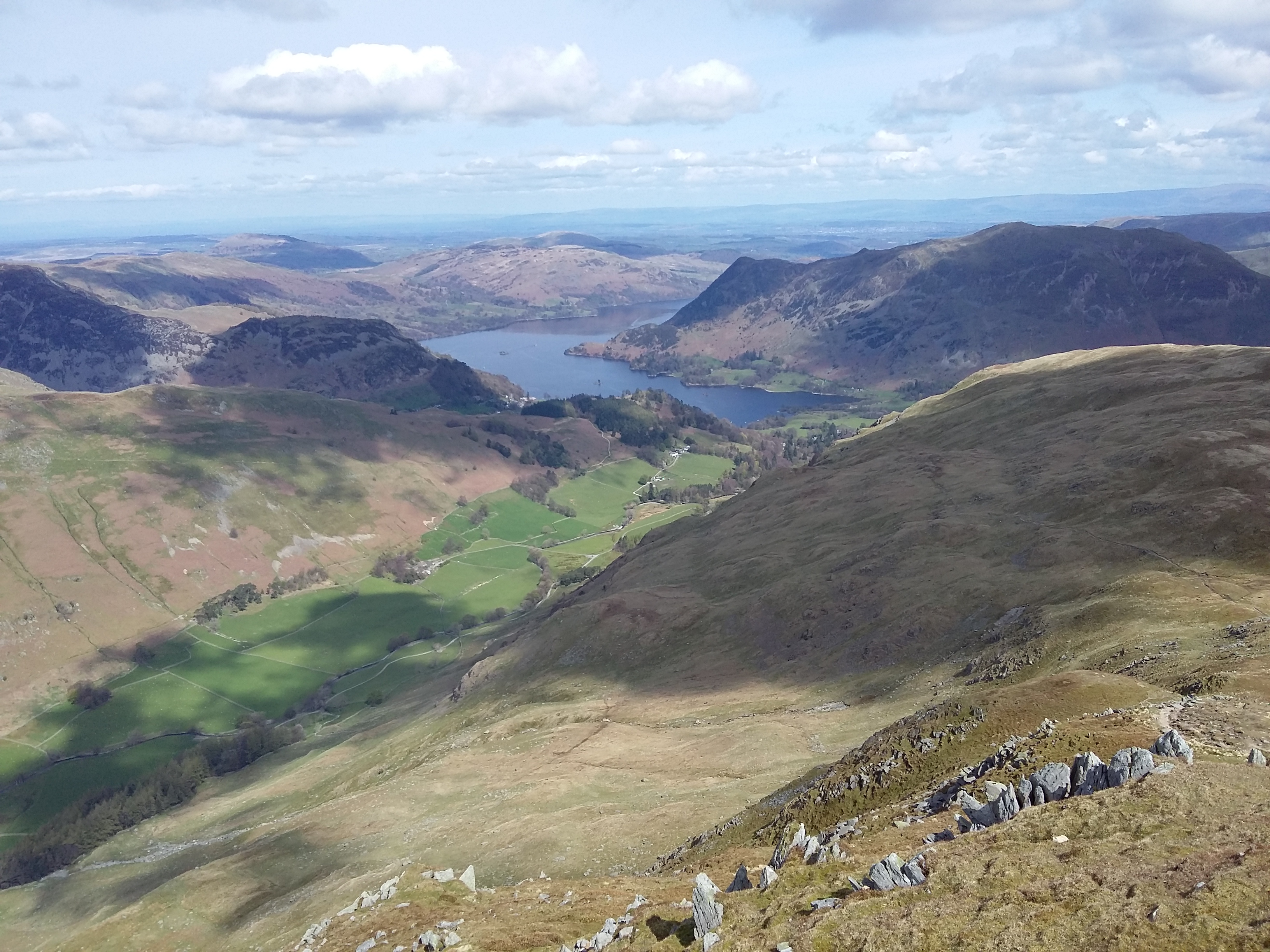
The views descending to Brownrigg Moss and along the ridge to Helm Crag were incredible, and there wasn’t a breath of wind. We stopped on an outcrop to take in the landscape looking towards Grasmere and Ambleside. I thought back to when I was last on this ridge in a howling gale and torrential rain and had to retreat down the hill side.
We went straight to the YHA to pitch our tents, have our first shower after 3 days of walking, and I did some laundry. Clean hair and dry socks felt incredible. Rich’s sleeping bag got quite wet last night so he hung it up in the drying room – I put my shoes in there along with my laundry, and they were toasty warm and dry the next morning.
Grasmere boasts a Co-op, a Cotswold Outdoors, the smallest gingerbread shop and many cafes. We visited all of these. I bought some gas from the Cotswold Outdoors as a backup, unsure how long my small canister would last – after they saved me from buying an incompatible pin push one.
Grasmere YHA: £9 with a YHA card. Camping in a small field in front of the main building. Campers have access to the self catering kitchen, toilets and showers.
Pint: Kingstone Press Cider

Day 4 – Grasmere – Patterdale
8.5 miles, 1035m ascent, 6 hours
It had been a cold night, and the tents were frozen. We cooked breakfast in the self-catering building, and gathered our things from the drying room. My boots were dry and I was happy. It was a gorgeous day, crisp and clear, a gentle breeze and shining sun.
Rich was walking to Windermere and getting the train home, so we said goodbyes at the YHA entrance, and parted ways.
After crossing the A-road an elderly man greeted me as he walked up alongside. He lived just down the lane, and walked the stretch of this path up to the gate every morning before breakfast.
Near the top of the climb to Griesdale Tarn, an elderly couple greeted me and stopped to chat. They soon became my new heroes. They’d wildcamped at the tarn overnight, and were at the end of a week long camping trip in the Lakes. His pack weighed 5kg max (we had trouble converting lbs to kg) and we talked about gear. Clearly I have much to learn!
With the weather being so nice, I added a detour to the normal route, which descends in the valley after Griesdale Tarn, and climbed up to Fairfield then along St Sunday Crag, a walk I’d wanted to do for a while. If I’d known quite how scramble-y some of the descents were, I might not have done so with my big pack, but the views were incredible. In hindsight, it would have been better to take the trail from the end of Griesdale Tarn up to St Sunday Crag, skipping out the scree slope to Fairfield.
Nevertheless, it was a walking delight, and I didn’t rush, savouring the good weather.
Side Farm campsite: £9 camping, good showers and toilet block. Washing facilities. Get there early to nab a flat site!
Pint: Wainright

Day 5 – Patterdale – Shap
15 miles, 1104m ascent, 7 hours
On the climb out of Patterdale towards Angle Tarn the wonderful views I’d had of the Helvellyn and Fairfield ranges yesterday were gone, and thick cloud was dripping off the tops.
A brief heavy shower hit me around Angle Tarn and I slipped on one of the stone slabs, bashing my knee. I ate a chocolate bar and felt better (story of my life). The rain eased as I headed up towards the Knott and I was thankful when bearing left to Kidsty Pike away from High Street which was covered in thick cloud. The descent down to Haweswater reservoir was quite steep, but the views were good. This water was longer than Ennerdale, and it would take a couple of hours to walk alongside it. It also definitely isn’t a flat path.
There’s a small village at the end with a plaque telling the story of the flooding of the old villages under the reservoir, and the construction of this hamlet for the workers’ families. After a short woodland walk I came across an honesty box and gleefully bought a capri sun and a lion bar.
The next few fields had signs warning of bulls, but I only came across a small herd. Typically, they were in the middle of where I wanted to go. The path was unclear, so I struck up the hill out of sight of them, and reached the style going around the top. Bull avoided.
Some undulating fields and an old monastery later, I arrived in Shap. Shap has a medium sized Co-op and a small post office. It also has two pubs, neither of which I can highly recommend, unless you’re from the south and fancy the novelty of paying only £2.80 for a pint. It does, however, have the best fish and chip shop in the country. It’s won various awards, and they do free chip refills. Yeah.
New Ing Lodge: £5 camping, right next to a railway line. Caravan toilet, no running water. *Edit December 2017* – it seems New Ing Lodge has had a complete revamp, and from the website looks like the facilities have greatly been improved!
Pint: Whitbread

Day 6 – Shap – Kirkby Stephen
21 miles, 635m ascent, 8 hours
Today was going to be a long one, so I wanted to start early. No one appeared when I went to ask for water, but thankfully I had enough left over yesterday for breakfast. I left some money under a plant pot and set off, stopping at the public toilets on the main street which were in much better condition than the caravan.
After crossing the railway line and the M6, I walked onto the first moorland section of the C2C. The route for this on the map looks odd as it diverges from a perfectly good green dotted line and makes its own way across the moor. On the ground it made perfect sense, and the route was clearer than the designated footpath.
Once out of the moor I descended to Orton for the first cream tea of the day. I’d intended to go to the chocolate factory, because that sounded amazing, but I came across the cafe first and got distracted.
The rest of the day was mainly walking through fields full of lambs, trotting after their mothers who were startled by the intrusion. There were splendid views to the south of the Yorkshire Dales, and the miles disappeared. It was only the last half an hour or so on the road which made my feet sore.
“Have you come from Shap today? You’ve made good time!” the campsite receptionist greeted me. I looked at my watch, and I’d done the distance 2 hours quicker than I’d expected. Unsurprisingly, given that it was a proper campsite, with a modern wash block, the facilities were much better than last night. I had a long shower, twice.
Pennine View: £18 for 2 nights.
Pint: Addlestones

Day 7 – Rest day in Kirkby Stephen
Unsure quite what I was meant to do on a rest day, I decided eating lots and moving little were a good idea. Also, laundry. I hung out my clothes to dry on a line attached between my tent and my walking poles, then wandered into town for breakfast. Full english, plus milkshake. I then cafe-hopped for most of the day, interspersed with browsing guidebooks in outdoor shops.
I saw a poster in one of the shops for the town’s film club, which happened to be tonight. Why not? I had dinner in a pub which was having it’s first day, then joined the residents of Kirkby Stephen in watching Bridget Jones’ Baby.
Pint: Coast to Coast

Day 8 – Kirkby Stephen – Reeth
22.5 miles, 1289m ascent, 10 hours
I’d seen on twitter yesterday that a section of a new path over the bog on Nine Standards Rigg had been completed the day earlier. I’d heard about this via the BMC earlier in the year, but hadn’t thought it would be finished yet. Good timing! They’d put in a fixed post for walkers to take photos of it, so they could monitor the recovery of the vegetation, and I thought it was only fair to oblige. Looking at what the flagstones went over, I was very grateful for the path, as it seemed I’d have been swimming otherwise! It may have taken care of the worst, but there was still plenty of bog to go around in the rest of the route down the other side. The path would carry on nicely for a while then deliver you to a bog chasm. Most were just about jump-able, but my right foot got sacrificed a couple of times. I was thankful for my poles, which were doubling as bog-depth-checkers – some which looked shallow ate my pole to mid-thigh height, so I looked for another place to cross. Once you reach the cairn the worst is over.
I reached Keld by 1pm and had a lemonade and mars bar in the pub. I’d planned to stay at Rukins Lodge campsite in Keld tonight, but it seemed a shame to waste the good weather. I said as much to Dave and Barry, who arrived at the little cafe as I was just leaving, who had also camped at Pennine View last night. They agreed, but were staying there.
I pushed on to Reeth, 10 more miles. I felt good and had already done 12 miles, so it seemed a good idea. If you do so, I would recommend taking the valley route. Unless you have a keen interest in abandoned mines, the high route has two further climbs then bleak moors/scrubland wasted by mines. Apart from the odd explosion of grouse, there were no birds. The gradually declining gravel jeep track out the other side seemed to go on forever, and I picked up a massive blister on the pad of my right foot. I eventually arrived at the Orchard caravan site, tired and with sore feet.
In the King’s Arms I met Nick and Mike, a pair doing the Coast to Coast staying in B&Bs and using the packhorse service for their bags. We compared mileages and trip plans.
Orchard caravan and campsite: £8 for camping, 20p for shower, 20p for hairdryer.
Pint: Tour de Wot

Day 9 – Reeth – Colburn
12 miles, 460m ascent, 6 hours
When I emerged from my tent in the morning Dave and Barry, who I had left in Keld, had appeared overnight – apparently I had shamed them into continuing walking! We all had blisters from the long gravel stretch, which of course they blamed me for.
I was pretty tired after yesterday’s long day, so I took it leisurely today, as it was only 12 miles without major hills.
A poster on the way into Marrick advertised refreshments at the church, so I went for a look. A man in a clerical collar was strolling back and forth at the entrance and greeted me. I mentioned the poster and he seemed unsure but welcomed me in. I took a juice box and got chatting to the man, who turned out to be John, retired bishop of Oxford, now living in Richmond and doing local services -it was his first time to the church and he was waiting for someone to let him in.
At the top of the short climb I sat for a while on a convenient rock and looked over the valley below. In Richmond I followed the crowds through to the main market square, and found a tea room for a break. I have a nose for tea rooms. Cream tea demolished, I carried on a riverside path for a mile or two to Colburn.
Now, let me introduce you to the heroes that are Dave and Fiona, owners of the Hildyard Arms. They let campers stay for free in the back garden (on the assumption that you will eat in the pub) and have converted a toilet/shower outhouse which is open all the time. They don’t do food Sunday evenings, but when I arrived a bit before 3pm they put aside a Sunday lunch so I tucked into a roast dinner after my shower. They asked if I wanted pudding. I’d assumed there wouldn’t be any, but a cheesecake with extra ice cream (“You look like you could do with a second scoop”) appeared. I sat in the pub reading and charging electronics, and writing up some notes from the trail. When it was getting dark I headed out to go to sleep. Fiona came out with me and we commented how cold it was.
“Hey, why don’t you sleep in the caravan?”
Not wanting to protest too much, I packed up my tent whilst Fiona put a heater on in the caravan, and I slept in a bed in the warm. They wouldn’t take any extra money, and in the morning I got a full English breakfast. Felt like I might roll the rest of the way to Robin Hood’s Bay, but it was delicious.
Hildyard Arms: free for campers when eating at the pub.
Pint: Drummer Boy

Day 10 – Colburn – Ingleby Cross
21 miles, 179m ascent, 7.5 hours
Feeling well rested from the caravan and full english breakfast, I set out for Danby Wiske. The forecast was heavy rain first thing, and despite a sunny start, black clouds were looming and I only made it through 4 fields before I stopped to put my waterproofs on.
A sign was fixed to a footpath gate next to St Giles Farm, notifying of a diversion to the C2C path due to widening of an A road. The diversion was along the road, so the next mile saw me trotting along next to roaring lorries splashing up tidal waves. A couple of miles later and the rain had stopped and it warmed up, so I stripped out of my waterproofs, now overheating.
I saw Barry and Dave a few fields ahead, but they took a different route so I lost them. My feet got soaked walking through fields with long grass – the farm had set aside border paths in their rapeseed oil fields, but they clearly didn’t get used often enough to impact on the grass. I signed a logbook of walkers, and saw that there hadn’t been any C2C-ers so far this year.
I arrived at the pub in Danby Wiske just after midday, and my dreams of tea, lemonade, crisps and mars bar, which had occupied my mind for the last hour or so, were fulfilled. An american with a small backpack arrived a little after, ordered a pint and drank it within 5 minutes, then set off again. He’d started from Richmond today so was clearly pretty speedy.
It was the same situation as Keld – I’d planned on staying at Danby Wiske tonight, but it was still early. The guys had mentioned they were heading to a pub in Ingleby Cross, at the foot of the big hills we’d been walking to all day, and another 8.5 miles away. It was flat, and I’d already done 12, so carried on.
The day was dominated by pastural fields, walking through many small farms, and lots of vibrant rapeseed oil. There were also lots of showers passing, most of which thoughtfully went around me.
The crux of the day was the mad dash across the A1. Thankfully the Blue Bell Inn is just afterwards, so a pint to calm our nerves was readily available.
Mike & Nick, Dave & Barry and I convened for dinner and compared notes over the walks so far.
Having already been quite cold some nights, and with the temperatures forecast to go well below 0, I asked Sam behind the bar if they had a spare blanket or rug, thinking I was being a bit cheeky, but she came back with a full duvet. Never hurts to ask! I gleefully showed off my wares to Dave & Barry.
Blue Bell Inn: £7.50 for camping. Toilet and shower in outhouse.
Pint: 1863

Day 11 – Ingelby Cross – Blakey Ridge
19 miles, 1100m ascent, 8 hours
The dew was frozen on my tent again, and the duvet had gotten a bit damp from condensation, but I’d been as snug as a bug. The sun was shining bright, and we were dubious about the forecast of snow, but things change.
5 minutes up the road a box advertising homemade flapjacks stopped me in my tracks, and I fished out £1 and stuffed an apricot and date version into my pocket for later. The footpath diverging from the 4×4 track didn’t materialise, so I stayed on the track as it just took a longer way up the hill. After a few switchbacks I found the nearly disguised dirt trail heading almost straight up the hill, and was thankful for my poles in keeping stability. It spat me out on the top of the moor, whereby you immediately descend almost the whole height back down to a road. After some woodland walking the path climbs back up onto the moorland.
Then the rain came. And the wind. I didn’t mind the rain too much, but the wind was so strong. I looked to the north across the flat fields and could see the storm cells lining up heading in my direction. A group of trail runners overtook me, and we made some typical British comments about what a lovely day it was.
I stopped at Lord Stones for a cream tea, and after some thought asked to borrow the cafe’s phone (my mobile had no signal). I called the Lion Inn, my destination where I had planned to camp, and booked a room in the pub instead. The forecast was for the rain to turn to snow, the temperatures to drop, and the gale winds to continue. There were no points for suffering on my walk, and I knew I wouldn’t have a fun night’s sleep without full winter gear, which I didn’t have. I immediately felt better after calling them; no matter how wet and blown about I got today I would have four walls and a roof over me tonight.
The american showed up as I was leaving, and he was also heading to the Lion Inn today. Mike & Nick were splitting the day in two, with a local B&B picking them up from a halfway point, so I wouldn’t see them again.
There were two more sections of climb to the top then back down to the road, and then it was up to Urra Moor. As I was just starting to ascend I looked to the north and saw a storm cell rolling in, so dived under a stone wall. A hailstorm gusted through in 5 minutes, then I carried on. Up on Urra Moor the rain turned to hail then a full snow storm. I made a little detour to the trig point to get the highest point in the North York Moors national park.
The snow gradually eased, but the wind remained. The last section is on an old railway line, with one long straight raised section. I was quite concerned I was going to get blown off it several times, and I just ploughed on head down trying to get to the other side as quickly as possible, with my walking poles anchored at almost 45 degrees leaning into the wind.
The railway path seemed to go on forever, and even when you turn the last corner and the Lion Inn finally comes into view, it still takes half an hour to get to it. And it started raining heavily again.
“You look tired!” a local (as local as you can get to the remote Lion Inn) remarked as I deposited my wet backpack at the foot of the bar. “Sounds about right!” I was knackered. 21 miles yesterday, 19 today and barely being able to walk in a straight line all day. The landlady came and showed me to my room – a smaller, cheaper one had become available after I had called earlier, which I gratefully accepted. She showed me the private bathroom across the hall, which contained a bath. Now, I’m a shower rather than a bath person, but I almost squealed when I saw it. I ran it to near scalding and must have soaked for about an hour. Leaving electronics to charge, I went downstairs in search of food.
“Are you with two guys?” the barman asked. “Oh are they here?” I asked excitedly; I’d wondered if they were going to stop earlier. “Yeah they were asking after a girl by herself, they’re just pitching their tents somewhere.” “They’re doing WHAT?”
Dave had decided he wanted to camp the whole trip no matter what, which meant Barry had to sign up too. Men. We ate dinner by one of the many 1000 degrees fires dotted about the pub, as I tried to reason with their stubbornness. They headed out into the blizzard after, and I wished them luck.
Lion Inn: £2.50 to camp next to the pub, B&B rooms start at £25.
Pint: Golden Pippin

Day 12 – Blakey Ridge – Littlebeck
17 miles, 487m ascent, 7.5 hours
I looked out of the corridor window and saw patches of grass amongst the snow where Dave and Barry’s tents had been. Either they’d started earlier or they did indeed get blown away. I found them by the fire having tea and toast which the pub had refused to take money for, probably worried about hypothermia. Unsurprisingly, they hadn’t had a great night’s sleep, mainly because of the noisy wind. Men.
It had snowed a lot overnight and was still going, and whilst the wind had thankfully lessened it was still pretty gusty. With the poor visibility for air and ground, I stuck to the roads rather than taking the footpath shortcuts as they were minor tracks which I feared losing in the snow/putting my foot through a hole. After I thought I’d been walking for quite a while, the cloud lifted and I could still see the Lion Inn behind me. Bugger.
I was thankful the bridleway leaving the road was a solid 4×4 track, easy to follow in the snow. Near a hunting hut the sun came out, and with worries of navigation and weather disappearing, I drew pictures in the snow and wrote notes for the guys behind me.
Coming down off the snowy moors into Glaisdale was like walking from winter to spring. I had to quickly shed my waterproofs before overheating in the sun! I stopped in the pub for lemonade and a bowl of chips.
“Now there’s a fit young girl!” an old man with his wife hailed me as I was leaving the pub. I knew he didn’t mean it to sound like I heard it, so I opted for deflection. “Or broken…” Apparently they were the advance party for their grandchildren doing the coast to coast, who had also been staying at the Lion Inn. The grandchildren were in their 20s though, so quite what support they needed I never found out.
Dave and Barry strolled down as I left the pub (again) and headed inside for refreshment, as I carried on. On the road to Grosmont a red van stopped on the opposite side of the road and a man with a long white beard and fluoro yellow beanie hailed me over. Not getting the child-catcher vibe and intrigued, I obliged.
“I don’t mean to be obtuse, but what do you use those walking poles for?” he asked. He was a keen walker but his knees suffered on the downhills now, and had never tried poles before. Being a convert to walking poles since a couple of years ago, I happily explained how much they help with rhythm, balance, support, taking weight off, bog-depth-testing etc. I had to dodge the odd car but he was interesting to talk to.
I rounded the corner into Grosmont and, naturally, stopped at the tea room.
The climb out of Grosmont took me by surprise, and was probably the steepest of the whole trip, on a narrow road. As it eased off, I was taken aback when I realised I could see the sea! I hadn’t thought that I would be able to today. It looked so close! Marvelling at how the walk was almost over, I pushed on over the small moor and down into Littlebeck to Intake Farm.
I called out to the farmer and enquired about camping. He seemed unsure at first but quickly warmed, and showed me to their garden where I could pitch my tent. He explained his wife was shopping in Whitby and she dealt with the lodging. I set my tent up in the sun then sorted through my pack.
A while later a “Hello-oo?” came round the corner. Judith was back and spotted a tent in her garden. I clambered out and introduced myself, and she invited me inside for tea and cake. Dave and Barry arrived as we were heading in, just as I was starting to wonder if they’d decided to push on instead of stop here. If you booked the camping you could request dinner too, but as we’d just turned up and they had no B&B guests, we cooked our own outside. The weather was the complete opposite of how the day had started, and I cooked a Firepot spaghetti bolognese – a new UK expedition food company, and the first dehydrated meal where I recognised all the ingredients, and tasted very good!
Intake Farm: £6 for camping, £1 shower.
Pint: Yorkshire Cider

Day 13 – Littlebeck – Robin Hood’s Bay
11.5 miles, 425m ascent, 4.5 hours
With buses and trains in mind, we decamped early and I told the guys I’d be in the pub by the sea.
After descending back down to Littlebeck, the climb out the other side was along a lovely woodland trail, with some board walks over muddy sections. Once at the top, it was just two sections of moorland to the coastal path. Easier said than done. The path on the first section starts off all very well, then within 50m of the border style, abruptly disappears into bog. So much for dry feet on the last day. The next section had some pretty deep bogs too, and I took some large detours around the worst.
Out the other side I was funneled down a muddy, stony track until it emerged onto a road. Solid ground. I popped into a caravan shop for some final chocolate bars, then carried on. There were road signs up for the Tour de Yorkshire tomorrow, and it was a shame that the days hadn’t quite aligned, but it would also have made crossing the roads more difficult!
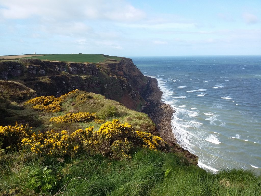
I considered stopping at the cafe in Northcliff holiday park, but continued down to the cliff path. I savoured the last 3 miles along the cliffs, wanting Robin Hood’s Bay to appear and also not. Eventually I rounded one last headland and the little town came into view. I walked down the steep narrow road to the beach, and took out the pebbles that I’d carried from St Bees. As in St Bees, the tide was far out, so I walked a suitable distance to some tidal pools, then threw the pebbles as far as I could.
It started raining so I went and had a yorkshire pudding the size of my face in the pub, and Dave & Barry appeared about an hour later. We congratulated each other on the 190 miles and the crossing of our country.
We made a dash (as much as three hikers can dash after two weeks) for the bus stop in the rain, and I almost nodded off on the ride to Scarborough. We quarantined ourselves at one end of the cafe at the train station and did some feet care – Dave tending to his blisters, me changing to dry socks. We were on the same train out, then I changed at Lancaster after a quick farewell to the guys – and good luck to Barry, who was off tackling the Pacific Crest Trail in a couple of weeks time. Maybe one day…

I enjoyed that Kat. Beautifully written. It was fun following you on Twitter. I’m currently in Aviemore heading to the campsite at Loch Morlich to meet my wife who’s nine days unto the TGO Challenge. If you fancy trying wild camping it’d be right up your street.
Thanks Geoff! Your photos are great – Scotland is definitely on my adventure list, trying to decide if by hike or by bike 😉 And wild camping is on the list too!
A wonderful read. Thank you so much fro sharing!