September 2021
This is a trip report of bikepacking a section of the Scottish part of the Great North Trail and the Great Glen Way. The Great North Trail is an off road long distance bike trail choreographed by Cycling UK that starts in the peak district and ends at either Cape Wrath or John O’Groats, with a mix of bridleways, quiet lanes, single track, double track, forestry roads and access roads. The Scottish leg is less technical than the Pennines, with more gravel tracks than bridleways, but is more remote. The part we rode is also on the An Turas Mor route.
A little compilation video of our riding, with the view from my handlebars:
Day 1: Milgnavie to Loch Lubnaig
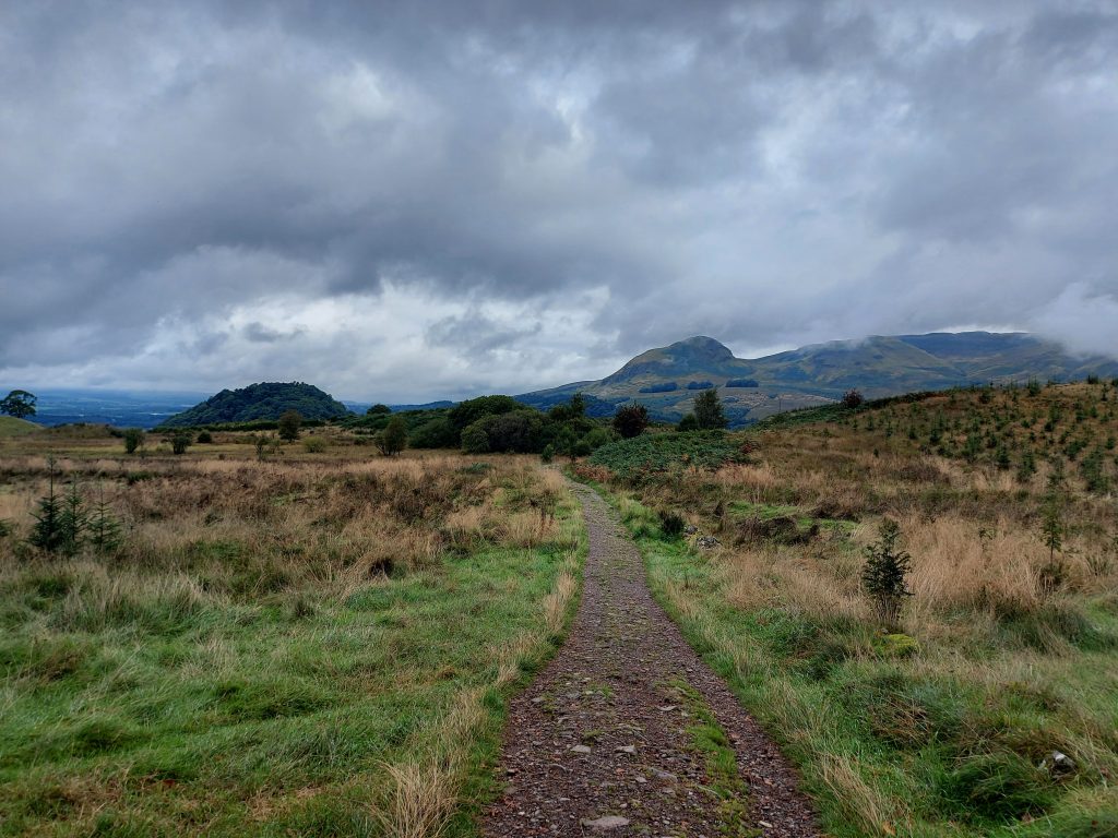
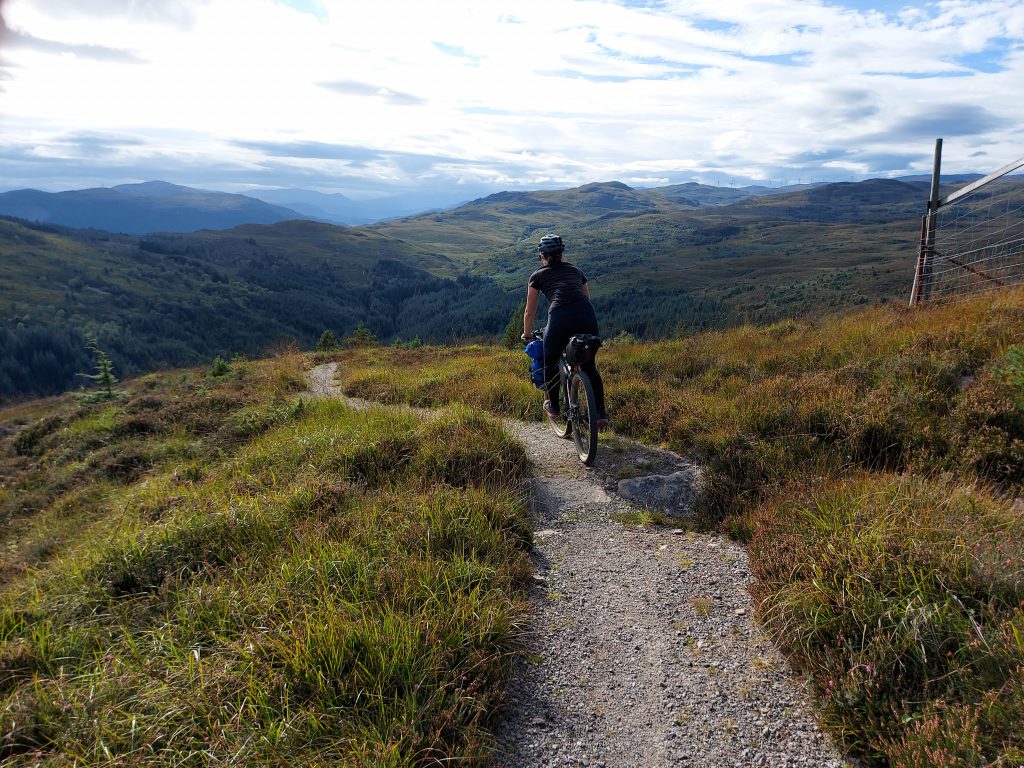
Just about managing to the find the massive West Highland Way start sign, we set off from Milgnavie in the morning sun. Immediately we were out of the suburbs, rolling along a woodland trail. Some reservations about the rest of the trip arose when a steep little climb had us pushing the bikes within the first hour. But we were in some fabulous scenery already, wiggling between the Kilpatrick Hills and the Campsie Fells.
The terrain varied between dirt track, gravel path and rocky road, single track and double. We passed walkers in waves, grouped together by the arriving train times. On a September Friday morning it wasn’t too busy but we were still glad that Barbara had a bell, and there was a lot of “Hello…thank you!” as people stepped aside for us. I imagine it would get a little tedious on a weekend. There’s also a lot of gates on the WHW as it goes across the edge of farmland, which aren’t always the easiest to navigate on fully loaded bikes.
At Drymen we left the WHW and continued north through Loch Ard forest down to Aberfoyle. In contrast to the popular WHW, we didn’t see anyone on the gravel forestry tracks. The gravel turned to red mud for a section and in the rain I could see it being quite treacherous. There was a steep climb up through Achray Forest which started beneath a Go Ape site, with people nervously crossing high-wires above us.
The beautiful Forest Drive over Loch Drunkie zig-zagged us back down on light gravel. We met a man riding LEJOG on Sustrans routes, having been roped into it by a friend. A few days after he started he posted home four of his dress shirts to lighten his luggage. I didn’t find out how many he still had. Whilst we were zooming care-free down the track, he had to take it fairly gingerly on his thinner road bike tyres.
After an early pub dinner in Kilmahog we started up on the Rob Roy Way alongside Loch Lubnaig, looking for somewhere to camp. Loch Lubnaig is just within the Loch Lomond and the Trossachs managed camping zone, where you need camping permits in some locations. We carried on the path until we passed a sign reporting that it was the end of the permit zone. Hopes were fading somewhat as the left hand side was steep jungle, and the right hand side wasn’t much better, until I spotted a hidden path down to the loch shores.
It was Barbara’s first wild camp and the location set a pretty high standard – flat, soft, short grass in a small glade, with no midges and lochside views.


Day 2: Loch Lubnaig to Rannoch Forest
Twenty minutes of riding into the day and we thought that was far enough and had breakfast at a café in Strathyre at the end of the loch. Our colourfully laden bikes often draw people’s curiosity and it became normal for one of us to return from ordering food to find the other explaining to people where we were riding, what we were doing, and yes this was fun for us.
The morning was spent on the delightfully smooth surface of Sustrans Route 7 on a disused railway path. The sun came out as we rode over the viaduct in Glen Ogle. We got chatting to a couple travelling around Scotland in a campervan and riding loops around the lochs.
From Kilin we turned off the main road onto a little lane heading gently upstream along Glen Lochay. This gave us plenty of time to get nervous about the first significant climb of the route, the Lairig Nan Lunn pass between Glen Lochay and Glen Lyon. In reality, the hardest part was getting through the gate at the bottom. I walked up the initial steep section immediately after the gate as I couldn’t get on the bike at that gradient, but then slowly span up the switchbacks to the next gate. The tarmac was washed away in places and I was glad I was ascending rather than descending this side. Someone had spray painted FORZA ATM on the road at the top, and eventually we realised that ATM stood for An Turas Mor.
The descent to Glen Lyon was on a better surface and with views downs the valley, and of the Lubreoch dam. Having ridden up alongside River Lochay, we now rode down alongside River Lyon, on a lovely winding single lane road.
We made the Glenlyon Post Office tea room with 20 minutes to spare, and cleared them out of their remaining cakes and pastries. Probably one of the most remote and pretty Post Offices in the UK.
With a couple of hours of daylight left we started on the climb up over to Rannoch Forest, initially on a steep and rocky track. I startled a small group of deer on the path, which I almost missed due to focusing on navigating the rocks on the climb. It levelled out and we rode over the pass as the trail turned boggy, with large herds of deer across the plain.
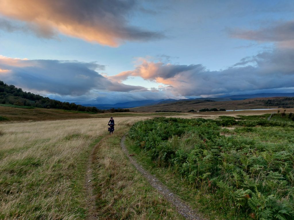
Descending through Rannoch Forest in the sunset was beautiful, and we had the valley to ourselves. We started looking for somewhere to camp and continued down and out of the woods as the only flat and open spots were turning points for forestry vehicles, and we’d rather not get run over if trucks appeared in the morning.
Crossing a river we rode up the jeep track a little further until we reached a flat-ish and sheltered-ish patch where we pitched our tents.
“It’s pretty cool how we can just be here,” I mused as we cooked dinner, surveying the lands around us and watching the stars come out.


Day 3: Rannoch Forest to Kinloch Laggan
Lulled into a false sense of security yesterday evening when there had been no midges, I was slightly alarmed to discover just how many I had brought back into the tent with me upon still bleary eyed after morning ablutions. Then I noticed a small tick crawling up my trousers. After trying quite hard in vein to kill it, I brushed it off outside. I retrieved my tick tweezers from my first aid bag, which thankfully was in the tent with me already.
“Barbara?” I called out, hoping she was awake and also keen to get going. Silence. “Barbara?” I extracted a tick from the top of my foot. “Baaarbara?”
I explained the situation. We started packing.
The jeep track was slow going, lumpy and with deep trenches that caught the pedals, and was surrounded by bog. But it was somewhat vindicating to discover that if we had carried on last night we wouldn’t have found anywhere better to camp. It took us about an hour to ride 6km but eventually we rode out of our glen and reached a paved road.
Ar Rannoch Station we had brunch at the wonderful tea room, which included mugs of both tea and coffee for each of us. Outside, distancing ourselves slightly from civilised society, we inspected each other for ticks and tweezered off a few more tiny ones. Fueled, caffeinated and debugged, we rode back down the road to the turn off for the gravel tracks north, on the Road to the Isles.
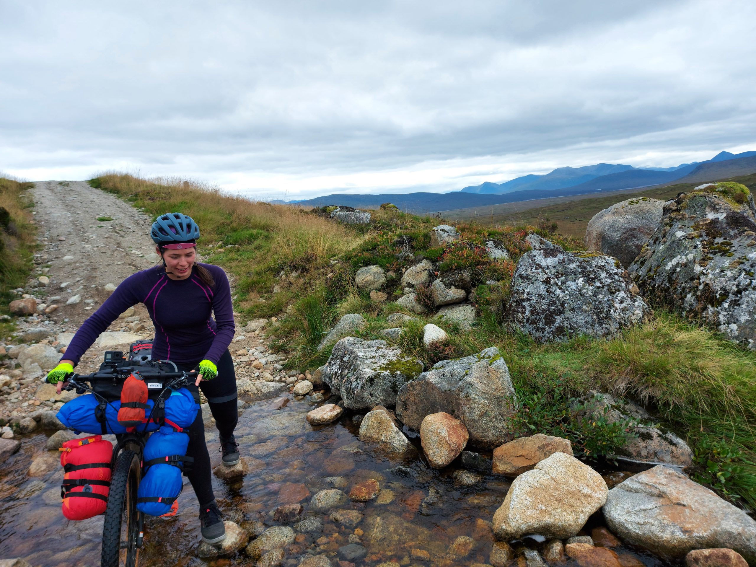
It climbed gradually into a sandy balcony trail along the side of a hill, with views over the plains of nothingness between us and far peaks.
“It’s rather pretty,” offered Barbara.
“It’s a bit bleak,” I countered.
“That too.”
The thick cloud above us felt like a ceiling we could almost touch. A few rocky streams required crossing, which meant dismounting and pushing the bikes across whilst trying not to lose balance and get wet feet. A rocky, long runout took us to the offgrid YHA, which we passed on the way to Corrour Station. A young man on a mountain bike with headphones in sped past us in the last kilometre. We leant our bikes near to his on the side of the building and followed him through the door.
It transpired that he actually worked there and had just been out for a ride, we had followed him into the kitchen, and they were in fact closed today, due to train strikes which cut off their main source of customers.
“I can do coffee and cake?” he suggested in response to the disappointment on Barbara’s face. This was met with enthusiastic thank yous, and he served us whilst still in his cleats.
The afternoon was smooth cruising alongside lochs, with views to the mighty Ben Alder and the Cairngorms, then swooping down empty valleys on light gravel roads.
I came to an abrupt halt at the start of a little climb in the Glen Spean woods as my chain jammed in the front derailleur as I’d tried to change gear. With some jiggery pokery I freed the chain, but then realised the force of the jam on my rear derailleur had pulled the rear gear cable almost all through. Borrowing Barbara’s large pliers I pulled the cable back through to get most of my rear gears back, but I couldn’t get the smallest two gears working again. I rubbed the oil off my hands and ate some chocolate.
Luckily the rest of the day was very flat, on a forest gavel track alongside Loch Laggan, through the Adverikie estate and past their giant castle. At the northern end the loch we rode down to the white sandy beach and looked back at where we’d come from.
Whilst reaching John O’Groats had been the default aim of the trip, neither of us were that fussed and it became apparent that at our pace we wouldn’t make it in the time available.
“Each day is enough for me, you know? This simple beauty is all I need,” contemplated Barbara as we rode along, agreeing that we had come to ride our bikes in Scotland for a bit, rather than to reach a particular place that was very hard to get home from. “Well, I would like a jacket potato.”
We rode a little off-route along an A road to find a clearing in a Forestry Commission entrance that was perfectly sized for two tents, and with a nearby pretty waterfall and river for filtering water.


Day 4: Kinloch Laggan to Fort Augustus
I returned to our camp spot to find no trace of Barbara. Whilst she was finishing packing everything onto her bike I had ridden 50m into the next clearing to test and readjust my gears from yesterday – I didn’t have the smallest two, but those were pretty small – and suddenly she had disappeared.
I called out, to no response. I went down to the river to check she wasn’t topping up her water bottles, no sign. Hmm. Maybe she thought that I was testing them on the road? After checking back in the camp spot, I started up the road to where we were going to rejoin the route. At the junction there was no sign, so I turned back around and asked a couple cooking breakfast next to their campervan whether they’d seen a cyclist come past.
“No, we saw you both yesterday and when you went past just now we wondered whether you had split up!”
To much relief all round, we regrouped when I started cycling back towards our camp spot; Barbara had ridden the wrong way along the road.
The aim today was Fort Augustus, the other side of the Corrieyairack Pass. A relatively short day, with a big climb, and a YHA booked at the end for a shower and to dry things out – it hadn’t rained so far, but nothing dries in a tent.
A steep short climb on a rough and rocky road up from Loch Laggan had us sweating in the morning sun instantly, but gave us great views back along the loch and the white sands. It also meant a long sweeping descent through a wood with red deer scattering as we rode through. We stopped, the deer stopped, and we stared at each for a while.
Through a gate at the bottom of the track we turned west and joined General Wade’s military road. Built in 1731 as a means of moving soldiers faster through the highlands to suppress the Jacobite risings, it is now a closed road unsuitable for vehicles, consisting of large stones and rocks. But up to Melgarve, climbing gradually along the River Spey, it was smooth flowing tarmac through another empty valley.
Riding around the closed road sign the rocks began. It was slow going as there were frequent drainage channels cutting across the road, made from large rocks, not all of which were rideable. I wasn’t sure if I was glad of them because it broke up the climb, or frustrated that it broke up the climb.
Reaching the notorious switchbacks I ended up riding about half of them, coming off on half of the steep corners in deep gravel, where pushing the bike was almost as hard as riding. The Corrieyairack Pass is on the route of two ultra-distance off-road bike races and I couldn’t imagine wanting to race up this.
The views from the top were stunning, and once again I thanked the weather gods for the conditions so far. Standing around became chilly so I put my jumper on to descend. We’d met no one on the ascent but I called out words of encouragement to some women riding up as we whizzed by. The long descent was rocky and easing off the brakes soon meant I had too much speed. I took a couple of breaks on the way down to give my brakes a chance to cool down, to admire the view, and to give myself a rest from focusing 100% on the ground. My thighs and back ached by the time I got to the bottom as I’d been out of the saddle the whole time.
The last little bit to join the road threw us down a narrow gorse corridor, which just felt a bit mean. We then rejoined General Wade’s road into Fort Augustus, and headed straight for a café by the locks on the Caledonian Canal, watching the boats go through.


Day 5: Fort Augustus to Beauly
Leaving our YHA room with a certain eau de camping smell, we were climbing almost immediately in Inchnacardoch Forest. My gears had decided to bunk off, so I found a flattish bit to stop and have another go at pulling more of my rear gear cable through with the pliers, then fiddled with the barrel adjuster as I was riding and managed to get all of my gears back. Not perfectly indexed, but it was a satisfying fix.
The forest trail was rocky and rooty, and humid amongst the bracken switchbacks. Sweat ran down my spine. We emerged from the forest earlier than the map would suggest; a large area had recently been cut down. The gradient eased and the rest of the climb was on easier open gravel road, and the top came quicker than expected.
The descent, however, was slower than expected, with the route leaving the perfectly decent gravel road and favouring a narrow and bumpy heather trail. The trail book had marked a 4m wide river here that might be too high to cross, but in our dry weather it was easily navigated.
We emerged at Torgyle Bridge, and rode a little off route to reach the Redburn café in Dundreggan. Whilst I tucked into a very delicious apple pie, we chatted to the owner about our ride and route. She told us about the Dutch billionaires buying up the estate lands and causing problems with public land access. The estate we were about to ride through had begrudgingly relented and reopened some gates, but the one to the south had essentially told the councils that they had more money than them, and if they took them to court they’d lose. This meant that locals that previously had been able to walk to the shores of Loch Ness were now blocked.
The second climb of the day was much tougher than the first. I rode as much as I could until my wheels slipped in the loose, steep rocks, walked a bit, then got back on the bike, ad infinitum (so it felt). I reached a plateau and the road zig-zagged up into the distance, alpine style. At one of the many times I stopped to admire the views, a pair on mountain bikes rode down and stopped for a chat. They were riding the Highland 550, a big mountain loop, and we shared our amazement at the weather, our admiration for the views, and our best café tips. They were the only riders we’d see all day.
A block of cloud and rain sat on the peaks to the west of us, but we descended into the sun amidst small sparkling lochs. We made a quick detour to Plodda Falls, which were pretty impressive, although we both felt a little queasy looking down from the viewing platform at how high up we were.
Down into Glen Affric we stopped at the old coach house café in Tommich, where a very overworked owner had run out of most of the food options as a coach bus had got stuck in a ditch earlier in the day, blocking anything going in or out of the valley, corralling people at the café. We were in no rush, and happy to sit in the sun for a while.
As we headed out, the chat quietened down and whilst the valley was very pleasant to roll through on the “old road”, a well-surfaced single lane road with no vehicles, we were both flagging somewhat. It became clear when we got to Struy why we had received blank faces earlier when we told people that was where we were headed – it was just a junction with three buildings and a church. A little further on we came to a hotel with some tables outside for a bar.
“…Pub?” “Pub.” We acquired some drinks and crisps from the bar. Neither of us were particularly enthused about finding a spot to camp on the next climb which was reportedly boggy and heather-y. I had a little search on maps for what was nearby, and we weren’t too far from an actual town: Beauly.
“Just throwing an idea out there,” I said to Barbara through a mouthful of crisps. “We could ride a bit further to a campsite in Beauly?”
“Oh short grass, excellent,” having developed an aversion to long grass from the tick escapades. This escalated quite quickly to having a rest day in a hotel and I gave them a ring to ask about bike storage. We’d planned nothing on the trip and it suddenly became apparent that a rest day was exactly what we needed, realising how knackered we both were. Group morale improved significantly as we rejoined the Old Road towards Beauly rather than starting another climb.
At the Priory Hotel I checked in and a very helpful Chris showed us to the bike storage – his workshop – and locked the doors once we had removed all the bags we needed from the bikes.


Day 6: Beauly
After sampling all of the baked goods in Beauly and looking around the priory of a rather obscure order of monks, thoughts turned to the next few days of riding. I checked potential train stations for where we might end our ride and return to Edinburgh for the Sunday train home, and quickly got confused by the ScotRail website. I gave them a ring. It was quite hard to convey that the time, date and location of the train was flexible, but it became apparent that it would be impossible for us to get a train to Edinburgh with two bikes from anywhere north of Inverness on Saturday or Sunday due to train strikes.
I had a little sulk at not being able to continue on the Great North Trail, then looked at alternatives. With some help from the Komoot app, we decided to join the Great Glen Way to Fort William over two days, then get the train to Edinburgh on Friday before the train strikes stranded us.
Day 7: Beauly to Portclair Forest
The day started with some small lanes to climb up over the mountain ridge between Beauly and Loch Ness, which included riding through the excellently named Cragganvallie. On a very steep road a delivery driver came down the hill but pulled in to let us (slowly) past.
“You’re doing great, keep going! Have a great day!” This has never happened on rides back home. It was quickly followed by riding past the fluffiest, tiniest cow I have ever seen. So far so good.
Once on the top we found the Great Glen Way and left the road for the gravel track. It began a swooping descent with fantastic views under the blue sky. On one of the (many) times I stopped to take photos a man walking up the hill stopped to admire the scenery with me. We asked the usual questions of each other and it turned out he had been walking for the last 6 months from Land’s End, and aimed to finish at John O’Groats in the next couple of weeks.
“I’m having a sabbatical and just started walking – first south to Land’s End and then north on LEJOG. I thought my tent was getting bigger but it was just me getting slimmer!”
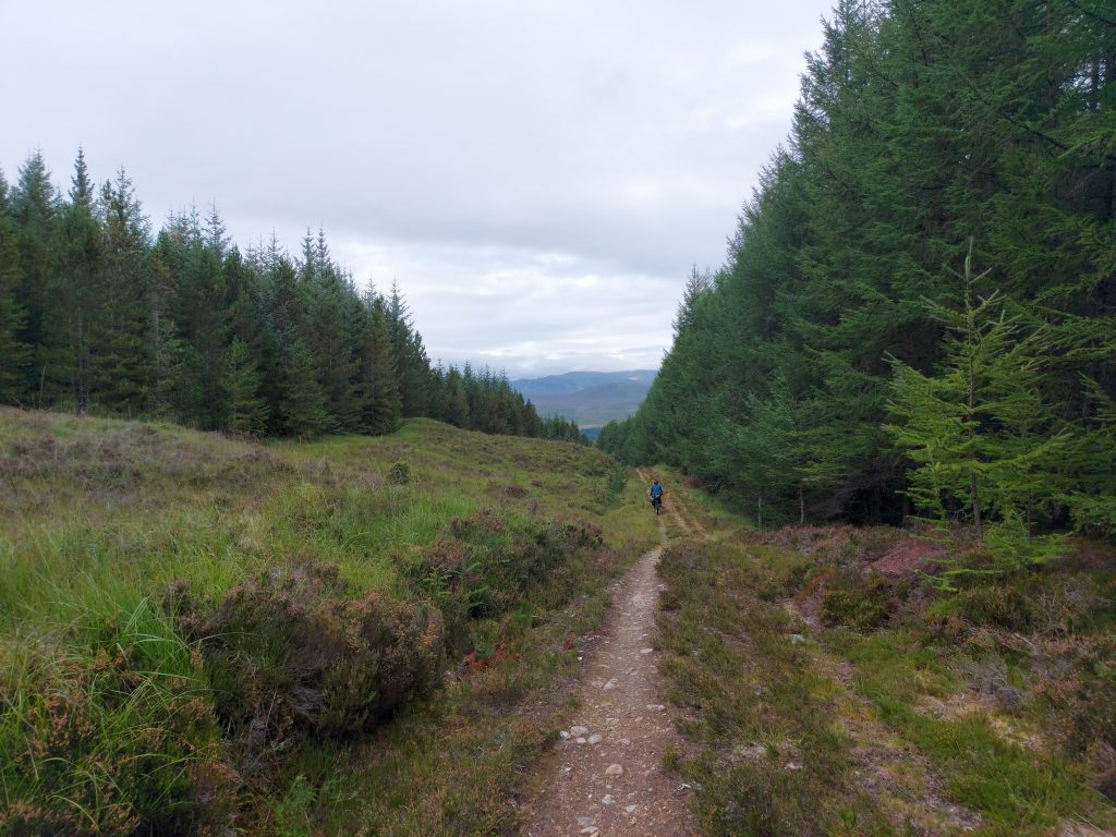
The gravel gave way to dirt paths in the forest, shooting down between giant conifers. A lunch stop in Drumnadrochit (Cafe Eighty2, very nice) was the break between climbs as it was back up the hillside straight afterwards, with more magnificent views along Loch Ness.
At a couple of points on the trail the GGW splits into a high and low route, and I caught up to Barbara reading the information sign.
“Low route: suitable for horses and cyclists.”
“But it’s such a nice day!” “It would be a shame to miss out those views, right?” We would come to see that the information sign had probably made a sensible suggestion, as we ended up taking our bikes for a lovely walk for quite a lot of the high route, due to the steep gradient, rock gardens, and steps. But the scenery was worth it.
In Portclair Forest the track eased from mountainous to undulating. Keeping an eye out for somewhere to camp but not seeing anything, when we passed a campsite sign we quickly agreed to take it. A short steep descent off the trail saw us pop out at the back of the campsite and thankfully they had room for us. It was a lovely little campsite and we cooked dinner on picnic benches, feeling very civilised.


Day 8: Portclair Forest to Fort William
Forgoing our porridge, we rode the short distance on the rolling forestry track to Fort Augustus for breakfast. After a second coffee, we started on the last leg of the trip, heading south along the Caledonian Canal. This was actually more interesting than I had been expecting, and didn’t stay right along the flat edges of the lochs all day, but darted up and down in the forests. We met a lot more cyclists and hikers on this trail than the Great North Trail, and everyone else was sensibly riding or walking south to north, with the tailwind.
Thirty minutes out from Fort William it started drizzling, and we donned our waterproofs for the first time on the trip. Ben Nevis was typically obscured by the clouds. Navigating the suburbs of Fort William, we rode into town and killed time in cafes until we could get the train to Edinburgh.


End Notes
I would highly recommend the Great North Trail to those in search of gravel days, mountain climbs, and glens to yourselves. We had to turn back before the most remote section, but the parts we did were stunning, although we were very lucky with the weather! My lowest gear is very low, and whilst I wasn’t moving particularly fast up hills in that gear, riding was much easier than pushing the bike up. We were never in a rush and had no fixed plans, our enjoyment was the most important part of the trip rather than pursuing any epic sufferfests in the name of speed. Wild camping allowed us this flexibility of riding however far we felt like each day. But if you wanted to ride with a lighter bike and avoid the midges/ticks then you could do some of the ride staying in booked accommodation. The route is designed for riding south to north and I would recommend this – many of the big climbs I was glad of the side that I was descending.
Logistics
We got the Caledonian sleeper train from London to Edinburgh. I rang the customer service team to check bike slots and they were incredibly helpful sorting out which trains had bike spaces available. With limited leave it’s the most time-efficient travel, and the least faffy with the bikes. There’s no way my bike would fit into the poxy GWR bike hooks. From Edinburgh we took two short trains to Milgnavie.
Gear Report
(And fitting it all on the bike)
My tent (the ever faithful Tarptent Scarp 1) was attached under my handlebars with a Revelate Designs Harness. This meant I could remove the tent dry bag without having to unstrap the holster from the bike each time. The Scarp doesn’t pack down particularly small so it makes fitting everything on the bike a bit harder, but I love it too much to get a smaller one. Plus, with flat handlebars there’s no width limit for strapping bags underneath like there is for drop bars. In the same dry bag was my sleeping mat, liner, and pillow.
Also on my handlebars was a Jones loop bag that fits on top of the tent and in the Jones bars loop. This held bits that I wanted accessible in the day – midgespray, alternative gloves, snacks etc. I had a 1 litre dry bag strapped to the front of the bars with my waterproof rolled up inside. Two funky Wizard Works cockpit bags either side of the stem held a water bottle, sunglasses, glasses, buff, chapstick, hand sanitiser, midgenet, pocket bag, mask and more snacks.
My fork has bolts to mount cages on the sides, to which I attached Salsa Anything Cages. Each one fits a dry bag strapped in, which holds my sleeping bag, towel, down jacket, first aid kit, and cooking gear – all the same as my backpacking gear.
I filled my frame triangle with a Salsa Exp HT frame bag. This is the most efficient way of using the triangle space as it can’t take two full size bottle cages. The front part has a water bladder, with the hose threaded through the front port and looped up the handlebars so I can sip and ride. The rest of the frame bag held an inner tube, gorilla tape, water filter and dirty water bladder, snacks and a jumper for easy access. On the thin left hand side of the frame bag I stored a little bag of toilet paper and a trowel. Leave no trace!
There’s bolts on the bottom of my downtube which I fitted a bottle cage to and filled a bottle with all my mechanical tools, with a voile strap as extra security.
Under my saddle I had the 14L Revelate Designs Terrapin. It’s a bit of a beast, but it cinches down tight. The main selling point for me is the removable dry bag from the holster, so you don’t have to attach it to the bike every day and you can pack everything up inside your tent out of the rain. The saddlebag held my clothes, electronics, washbag and food (oats, trail mix, 5 Firepot meals). The saddle bag has webbing on the top so I can lash any extras when needed.

The biggest changes from the original build of my Salsa Fargo were switching the handlebars to Jones bars with ergonomic grips, and the seatpost for a Thudbuster short-travel seatpost. The Thudbuster is too squishy for long road riding but offroad it’s great at absorbing the little bumps and ridges. I was jealous of Barbara’s front suspension on the long rocky descent from the Corrieyairack Pass but overall I was happy with my rigid frame. The Jones bars with erg grips were very comfortable and I as very happy to have no hand numbness or pins and needles, which I often get with drop bars or “normal” flat bars. I ran 2.25″ Vittoria Barzo tubeless tyres and the width was good for the tracks, no issues.
Gear highlights:
- Scarp 1 tent – the fact that I can put it up/have it packed in 1 minute is a big bonus when you’re in a cloud of midges/it’s raining.
- Rapha cargo shorts – I love the pockets on these and the chamois is my favourite. My pretty large phone stays firmly in place over rough ground.
- Merino leg warmers – these kept me cool in the heat and warm in the cold, and protected my legs from cuts, scratches, and insects.
- Nemo Fillo Elite Pillow – not quite sure why it’s taken me so long to get an actual pillow for camping rather than stuffing a dry bag with clothes, but it’s a significant improvement. It packs down tiny and is shaped like an actual pillow rather than a brick.
- FiveTen Pro Freeriders – I ride with flat pedals on my off-road bike and the Freeriders are very comfy to ride and walk in, and are amazingly sticky to the pedals.
Gear lowlights:
- FiveTen Pro Freeriders – they are not very breathable. The sweat from my feet made them smell pretty funky after a few days. I had to put them in a drawer in our hotel to stop them contaminating the room.
- Bikepacking bags – whilst they’re very good at staying put over the rough terrain strapped tight to the bike, they are a pain to pack every day. Once everything is in the bags it still takes faff time attaching them to the bike each morning. I might trial small panniers on the rear and test them off road.
I used all of my gear except the waterproof socks and the Garmin InReach. If it had been wetter I think the socks would have been nice, and I would always take the InReach.
Great post as always Kat. Really enjoyed reading about your bike-packing adventure. Inspiring stuff!!
Best Wishes
Paddy
Thanks Paddy! Hope you’re getting some muddy boot times too.
Recovering from mild Covid and this both inspired and entertained. Many thanks!