
August 2017
I had four days at the end of August to play with, and decided I wanted to be up a mountain on my birthday. I’d wanted to go to Scotland for a while – I would most likely get swamped by midges at this time of year, but I thought it’d be good practice for New Zealand’s sand flies.
I’d left it too late for trains apparently, and a return sleeper train was more than half my month’s rent. I had a look at National Express, and booked a sleeper coach up to Tyndrum leaving home Friday evening and arriving Saturday morning, and a sleeper coach back from Fort William to Oxford arriving Wednesday morning. I brought a set of clean clothes into the office before I left so I could change when I rolled off the coach, and handily the office has a shower.
The plan was four days of walking and camping, using the West Highland Way as a base. The WHW normally takes about a week, so I was starting further along. The WHW stays mostly in the valleys which I thought was a shame, so looked for some detours I could take up the hills. This isn’t a new idea by any means – I ended up buying and taking with me a book ‘Not the West Highland Way‘.
Approaching the weekend the weather forecast looked a bit grim, and I was prepared to just stick to the WHW in the valleys rather than battle the rain and clag on the tops if need be. However, as I stumbled off the bus from Glasgow at Tyndrum, the sun was shining. I dived into the Real Food Cafe for breakfast to revive me which was a surprise delight – highly recommended!
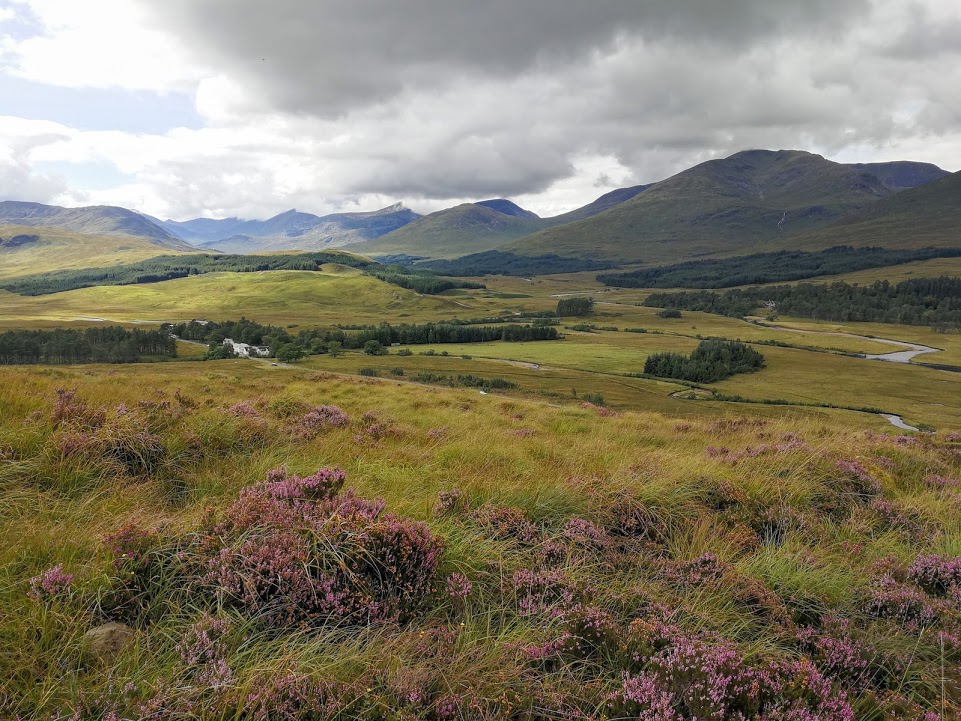
I set off along the WHW, passing a few campers packing up from the night – they’d pitched right next to the A82 so I don’t know how well they slept! It soon became apparent that the WHW is a motorway of a path; if anyone tells you they got lost on the WHW then do not let them be in charge of the map. The path follows the road for a while before winding down the valley basin and under (and then over) the railway line.
It began spitting as I approached the Bridge of Orchy Hotel so popped in for a bowl of chips and a hot chocolate (one after the other, not together). I read my kindle for a bit as the drizzle had turned into a downpour. After a while it eased off and I headed back out, up over the nose of Ben Inverveigh. I reached the cairn just after a french hiker doing the whole WHW, and we enjoyed the views together until we started to get bitten by midges.

I left the WHW to head into the Clashgour estate and began looking for a camp spot. There was just enough room for my Scarp next to the Clashgour hut. It was next to the trail path however, and despite knowing the camping permissions of Scotland, I felt a little unsure if I was okay to just pitch my tent there. I sat around for a little while, and a succession of trail runners headed past. Was I in the middle of a race?
Eventually I put the Scarp up, then sat with my kindle enjoying the unexpected evening sun and a breeze to keep away the midges. A few stragglers of the trail race trotted past, and commented on the nice spot I’d got. Some walkers came down off Stob Ghabhar and we had a quick chat about what it was like. I’d read up about the route and studied the map, but I was a little unsure whether it was a good idea or not – the book said there was some scrambling, and if it was raining then I didn’t know how safe I’d be with my big pack.
With the valley now all to myself, I filtered some water for the morning whilst my FirePot dinner was stewing. This was the first time actually using my Sawyer Mini filter and it was very simple, if not particularly fast. I was using the Sawyer pouch to fill up from the stream then filter into my Platypus – the Sawyer pouch filled up much better from a spout rather than a dunking in the river.
I slept much better than the previous night on the coach.

In the morning the wind had died to nothing and the midges were out in force. A few got into the tent when I ran out and in for morning ablutions, and one actually landed on my contact lens as it was en route to my eye. Luckily I carried spares. I decided on a cold breakfast rather than faff with cooking porridge in the midge storm.
Thankful for how quick the Scarp is to de-camp, I still got bitten. Bah.

There was more cloud on the tops than yesterday, but as I climbed the boggy path up Coire Toaig there was no rain in them. The wind picked up as I got higher, blowing the clouds around and every now and then lifting them up so I could actually see where I was walking.
When I reached the ridge running from Stob A’Choire Odhair I had a little food break and watched the clouds roll over the edge but never descend to the valley.
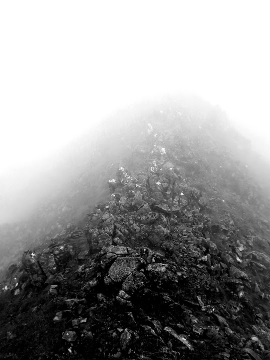
It was then a steep climb up to Aonach Eagach, now truly in the clouds. The scrambling was within my abilities even with the ~15kg pack which relieved me; I’d been prepared to turn around. Cairns told the way across a rock field where the path disappeared. Reaching the top of the steep section and swinging to the west, the ridge narrowed. I felt exposed but the wind was gentle and I took it steady.
It was truly quiet; with the muffling of the clouds, no one around me and no birds to be heard I was living in my 10m bubble of vision.
I reached Stob Ghabhar then followed the compass north-west off the top. I was prepared to navigate along Aonach Mor with compass and GPS, but when I descended to the plateau it was just below the cloud line. This made things simpler, and I took the direct line across to the Aonach Mor ridge.
I turned off down to Creag a’Bhealaich a little too early and ended up on a rather steep, rocky, mossy slope. When it flattened out I looked back and saw the easier line I could have taken. The right path is often easier to see in hindsight.
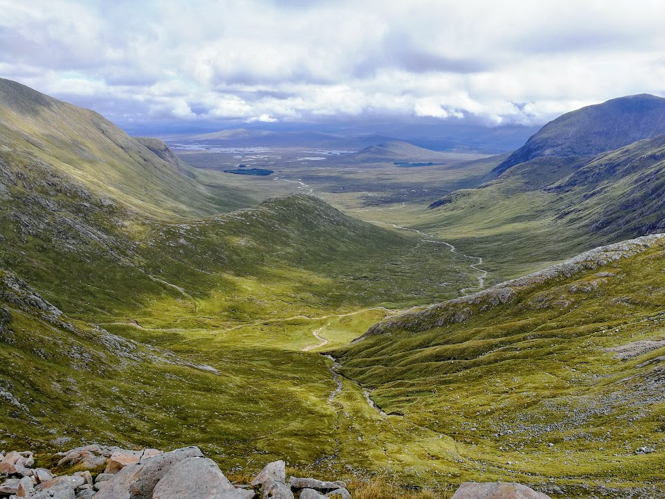
From camp at 180m I’d climbed up to 1090m then this ridge was back down to 697m. The sun was starting to appear at times though, and the views were spectacular. When the sun would break where I was walking it felt like it was shining just for me.
At the beginning the slope of Clach Leathad at the other end of the ridge looked impossibly steep. It was just a wall of rock. I double checked the guidebook, which said when reaching the steep ground, find the stream and follow it to the ridge. Right then.
I paused early on the ascent and filled up some of my water filtering from the stream. Looking at the mountains around me I felt surrounded by giants; this was my first time properly among the Scottish munros and they dwarfed my more familiar Lake District peaks.
I alternated between walking up the bog next to the stream, the mossy rock fall the other side, and the stream itself when it got smaller. I shortened my walking poles the most I’d ever used them and zig-zagged my way up. Of course it wasn’t impossibly steep as it had first looked, but it was definitely the steepest pathless ground I’d navigated.

Reaching the ridge it was then a relatively gentle ascent to the peak of Clach Leathad, in cloud once more. I then did something silly. I walked around the shelter cairn, had a handful of my trail mix, and started walking down the next ascent. It was a slightly north west descent to avoid the ridge drop, but I didn’t use a compass, figuring I’d just climbed from the south west so needed to turn 90 degrees left.
After a little while, the contours of the ground didn’t feel like they matched what they should be on the map. The ground was too wide. I checked the GPS, and sure enough I’d managed to do a 360 in the cloud and was now walking back down the way I came. Oops.
I turned around and this time bypassed the peak, contouring round to the north. It was another ridge walk to a cairn signalling the turn off for the crossing to Meall a’Bhuiridh. Not learning from earlier, I took a steeper route than entirely necessarily, only finding the easier way when half way down the rocky slope. From 1099m at Clach Leathad this went down to 932m, so wasn’t as big a drop as before. This meant the final climb was easier too, and a path had appeared for the way up to 1108m. It was windy at the top so I didn’t hang around, starting the long descent down to the valley floor.
I think Meall a’Bhuiridh is a mountain that looks better in winter. In summer it’s a mess of scree slopes, bog and eroded rock. There wasn’t really a path down to the chairlift plateau so I took a rather direct route which found me scrabbling down a steep bog slope in-between rock edges. There was probably a better way down.
My legs were grateful for the pause in descent, but at the plateau I was only half way down. There was a path now to the bottom that followed the line of the chairlift down to the Glencoe mountain centre. It was steep and quite severely eroded. I staggered into the mountain centre and had a slice of cake the size of my face, an orange juice, and a chocolate bar for later. The camping at the site didn’t look very appealing so I continued to the King’s House Hotel. It’s currently being refurbished so they’ve built a temporary bunkhouse. There’s camping out the back but I was knackered and I was pretty sure it was going to start raining heavily soon. I decided as I approached that if they had a cheap bed I’d take it, if not then I’d camp. They had one bed left, so that made that decision.

I opened the 4-bed dorm door to find 3 biker blokes laying out their gear. They were a bit surprised to see me, but were very friendly.
In the morning I cooked my porridge in the kitchen and watched the deer roam in the trees. During the night my bites had been added to (by midges, not the bikers) and my legs were rather worse for wear from yesterday’s big ascents and descents. I’d also hurt one of my big toes, which meant I was unconsciously rolling my foot slightly, putting strain on the ankle and shin. The clag had descended and it was raining heavily. Today was a slow waterproofs day.
I was sticking to the WHW today as the alternative in the book included a ‘dodgy river crossing’ which given all the rain that was pouring down the mountains, I didn’t think a sensible idea. It turned out there was a river crossing on this WHW stretch anyway – in the valley after the Devil’s Staircase section (a breeze compared to yesterday’s pathless mountain) a stream had swollen to cover the usual stepping stones and was flowing very fast. I walked up stream to find a suitable crossing point, and was grateful for the balance provided by my walking poles as the water came almost up to my knees.
Eventually the rain eased to a drizzle, but with the state my legs were in it felt a bit of a slog along the gravel track down into Kinlochleven.
The MacDonald hotel had a room for £90 or space for camping. That was an easy choice, and I went and pitched my tent in an interval in the rain. I spent the rest of the afternoon in the hotel bar which had great views at the foot of Loch Leven (and great sweet potato fries).
My toe had been hurting a lot on the day’s walk so I thought it foolish to continue walking the next day. At first I felt guilty for not walking but then realised how silly this was – I was walking for myself not for anyone else! Decision made I then relaxed and had a lazy breakfast before getting the bus to Fort William.
I spent the day cafe-hopping and pottering along the start of the Great Glen Way, before starting the Long Journey Home. I actually got some sleep on the return bus, I think the trick is to knacker yourself out. The bus pulled into Oxford at 8.45am, by 9.30 I had showered, eaten and started working. It might not be the nicest way of travel but the coach is certainly time efficient! I decided against hanging my tent out to dry in the office though.