This section covers the rest of Otago and the start of Southland.
Day 49: Wanaka to Highland Creek Hut
31km, +1300m -800m, 10.5 hours
We said goodbye to our lovely cottage and dropped the keys off on the way to the lake shore. From there we picked up the Glendhu Bay track, a gravel walk & cycle trail around the edge of the lake. We started off as the 5 of us but soon became staggered out with our different speeds.
It started off pretty flat but turned undulatory, which was to be the theme of the day. My bag felt very heavy as once again I had packed too much food. After a couple of hours we regrouped for a snack break, overlooking the lake back to Wanaka. The sun had now come out and we met Gina, a soft-spoken Australian.
Some mountain bikes whizzed past and I carried on, enjoying the lakeside views which reminded me of the Lake District. The trail flattened out as it drew alongside a road and then emerged into a holiday park. Ice cream! Not enough ice cream opportunities on this trail.
I somehow missed the path out of the holiday park and got to a locked gate so rolled my backpack over the top then clambered over. A long, straight dusty road led up to a car park and the start of the Motatapu track.
Ali, Liv and Gina caught me up and we had lunch at the beginning of the path in farmland, grateful for some shade as it was hotting up. The trail climbed gently through pasture land by the river, getting steeper as it entered beech forest. I was in a pretty forest and there was no wind, it was great.
The trail became steeper and I started to get frustrated at all the undulations, just pick up or down and stick to it. As I climbed out of the forest continuing sidling up the narrow valley the sun glared down at me. I wiped a flying ant off that had been drowning in my forehead sweat.
I staggered up to Fern Bern Hut, plonking myself down in the shade next to Sofia and Pontus. The plan had been to get to here and then carry on if the weather was still good, as the forecast was for rain and gales in the evening and tomorrow. I was tired but the sun was still shining and there was no wind so it made sense to continue. Present me would have to suffer some more so future me would be happier.
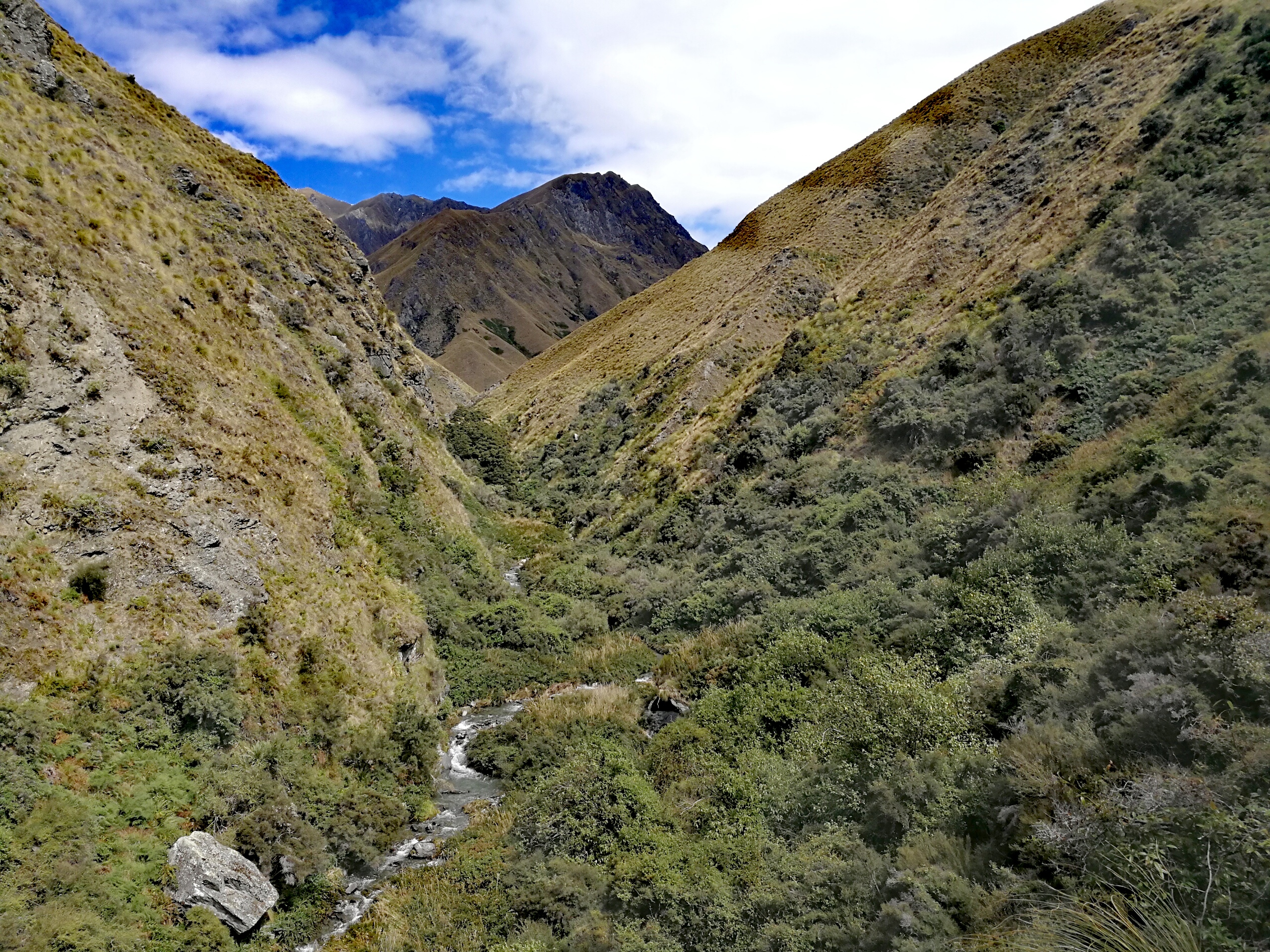
It felt weird to leave a hut at 4pm, but I started up another 500m climb to the pass. It was steep but less undulating, so I guess I’d got what I’d wished for. The sidling path was narrow and whilst it was clearly visible it wasn’t always solid – tussocks on the cliff-side edge of the trail made uneven footing.

The views from the top were stunning, just about possible to see back to Lake Wanaka, and the late afternoon sun on the sprawling green mountains was beautiful.
It was a long, very steep, narrow ridge walk down to a stream. My knees weren’t terribly happy by the end. I’d been trying to spot where the trail went next, thinking it would be along the river, when I saw Sofia and Pontus cresting another ridge up ahead. It was a cheeky 100m climb straight up the other side of the river, and then back down and around a bluff to finally come to Highland Creek Hut.
It had been a long hot day and I was knackered, but I was glad to make it in good weather. The hut was nice and new, and full with all of us, Laura and Charlotte, and some NOBOs. I had found some instant sweet potato mash in Wanaka and tried it for dinner, with salami and cheese. It was delicious and I made a second one, reasoning I needed the calories.
Day 50: Highland Creek Hut to Roses Hut
10km, +950m -1050m, 4.5 hours
I got a forecast from my Garmin as I made breakfast, which showed rain and cloud, but no signs of the gales originally predicted. Which was good, as we had two exposed peaks to tackle today. And going by comments from the NOBOs this section of track was pretty challenging.
I set off in the light rain, crossed the creek and began to climb up into the cloud. My calves started burning and I was sweating profusely under my rain jacket.
It was a steep climb up the ridge and then sidling round and up the mountain on a narrow path with tussocks on the uphill side, with not a lot of room to get round them, feeling like they might push me off the slope.
I realised I’d reached the pass as I started to descend. No views to be had today. It was a long steep descent along a ridge, then down the side of the mountain, down to a stream in a small beech forest. I caught Sofia and Pontus just as they were leaving, but stopped for a break, and Ali and Liv came a little later.
One peak down, one to go. It was straight back up the other side of the river and then a side round. The earlier rain had made some of the sections slick with mud and I slid on my arse down a small slope. I took my jacket off as it had stopped raining and felt much more comfortable.
A stretch of zig zags led up the face of the mountain to reach the ridge line. The switchbacks were a welcome reprieve from the usual ‘straight up and over’ New Zealand approach, but there were a few erroneous orange poles dotted about that made navigation harder than it should have been.
It was another calf-busting steep climb up the ridge, following a fence, and back up into the cloud. I felt wonderfully alone up there, the clouds muffling any sounds. The sidling required some concentration not to fall down the mountain, but once I was walking down the ridge with no views my thoughts could wander.
I descended below the cloud line and spotted the hut across the valley. Another knee bashing descent and then it was a short gentle climb to the hut, which was the closest I’d got to flat ground all day.

There was a note that a dead bird had been found in the water tank, so we filtered the water for drinking. I scrubbed the mud off my legs, changed into my clean and dry clothes, and then had a lovely afternoon lazing in the hut with the others as it started raining again.
Day 51: Roses Hut to Arrowtown
26km, +900m -800m, 7.5 hours
I checked the forecast again in the morning and the gales seemed to have disappeared still, which everyone was happy about. The cloud still covered the peaks but had lifted since yesterday and some sun was trying to poke through.
The day started with an immediate climb, and although cloudy it was pretty warm and soon I was dripping with sweat. It started on a grassy 4WD track and then turned back to a trail. There were long zig zags up the mountain side, but each zig connected with each zag by a steep vertical line, as if someone had only half understood how switchbacks worked.
An hour of labour saw me to the top, half in and half out of the clouds. I overtook Sofia and Pontus on the steep descent along and then off the ridge as Sofia’s knees were hurting. The views were stunning – the mountains were a sprawling mess of raggedy ridges.

I had a snack break at the bottom when the path turned to run along above the river, and the sun came out.
The next km was hell. The ‘path’ sidled up and down on the mountain edge, no wider than a sheep track. The mud was slippery and the path was angled down the mountain. Sometimes the next step just wasn’t there, having fallen away, but I couldn’t always see as it was covered with bracken. It went through gorse bushes, mauling my legs and arms, and at times I had to hug the gorse or be pushed over the cliff.
It took about half an hour to get through it, but eventually I emerged onto an outcrop and I could see the path got better ahead. I looked behind and could see the others starting the section and felt a pang of sympathy.
The trail was still narrow sidling but the gradient levelled out and the gorse retreated. I looked down to the river and could see a trodden path in the grass, criss crossing the river. Why didn’t the trail take that path? A short while later I descended into Macetown, a ghost town that had been lived in during a gold rush. There were plaques and some old buildings restored, but I carried on to find somewhere for lunch that wasn’t overrun with sandflies.
“What the hell was that trail?” we moaned at each other when they arrived a little later. Our knees and ankles were sore from the steep sidling and we’d all had enough of climbing over the last few days so it was an easy decision to take the alternative route on a longer, but fairly level, gravel track to Arrowtown, rather than up and over Big Hill.
The road went through lots of easy river crossings then rose up above the river, gently descending down the valley. I stopped when it came back down the river a few km later to filter some water as the sun was beating down hard.
The track rose back up, turning a corner, and meandered through the now dramatic gorge. As I got closer to Arrowtown several jeep ‘adventure safari’ tours came the other way, and some of the clients took pictures of me walking through the rivers that they were being driven through. On one crossing I couldn’t see the road come out the other side so just walked down the river for a while, but it was mostly ankle deep so it was pretty fun.
I emerged into a car park teaming with tourists, and was unsure where to go. I carried on for a bit and saw a cafe, hoping for an ice cream but found a cream tea, which was a level up in my eyes. I waved as Ali and Liv came out a little later, and then Gina, who had taken the hill route.
I contemplated ordering a brownie as pudding for the cream tea, but we decided to head to the holiday park to pitch tents before the rain came. It was an eye watering $40 for a tent site. It was the same price for 1 or 2 people so Gina and I were thankful we could share the site.
Arrowtown was nice but weird, feeling like an American West theme park. However, it had the closest to am English pub with a beer garden that we’ve found so far in New Zealand, and we had a lovely dinner and drinks celebrating another section done.
Day 52: Arrowtown to Queenstown
30km, +200m -200m, 7.5 hours
I woke to the pitter patter of rain on my tent. I got up just after 6 anyway as Gina was having an early start trying to make her shuttle in Queenstown for early afternoon as she had to race to get the trail done before her flight home. Gina had been a lovely addition to our trail family and we were sad to see her go.
I left before the others but didn’t get very far. I stopped at the bakery at the end of the high street and had a smoothie, hiding from the rain. By the time I’d finished the rain had eased and I headed back out, bumping into Ali and Liv.
The trail today mostly followed a gravel cycle trail to Queenstown so it was easy walking in and out of suburbs. It was a listening to music in the rain day.
It rained on and off as I headed out of Arrowtown centre and into a golf course. The New Zealand open of the Asian Tour was in progress so it was all a bit surreal. From there it was down to a lake and then up meandering along the edge.

The trail literally took us around the houses in the suburbs, I stuck with it but afterwards wondered why we didn’t take the more direct path to the river. I tried to find beauty in the river path but it was pretty dreary and industrial. The sun came out later and I regrouped with the girls, heading up to a bridge to cross the river to Frankton. Just before the bridge two men were unloading mountain bikes from their cars.
“Got your navigation sorted girls?”
We looked at each other, for a moment perplexed, 2 months without misogyny slowing down our processing time.
“Yes thanks, have you?” I threw back, but I’m not sure they heard. We crossed the bridge and had lunch at a picnic table the other side, which felt very civilised.
The trail continued through the suburbs of Frankton, where it was hard not to stop at every shop for a snack. I restrained myself to a twix and a peach ice tea. Normally limited to plain water whilst walking, the ice tea tasted amazing, and took me back to childhood holidays camping in France.
By early afternoon we reached the edge of Lake Wakitupu. From here it was a 7km flat, wide gravel path along the lake shore. Music back on, I went to see how fast I could get to the beer at the end. It took just over an hour to the park, where I waited for the girls and we walked under the arch to the lakefront plaza where the trail officially ends on the north side of the Lake Wakitupu hazard zone, just as it started raining. We dived into an Irish pub and emerged once the rain had eased and headed off to our hostel to find Sofia and Pontus.
After showers, laundry and tent drying, we went for dinner together with Linda, AK and AK’s partner Jonas, and it was lovely to see them again.
Day 53: Queenstown
Rest day. Delicious cooked breakfast, extended my phone SIM, food resupply, bought some toe socks (I’d managed to lose a pair of socks a couple of weeks ago) and gurney goo (to see if it helps keep my feet happy when wet), booked our shuttle for tomorrow morning around the lake, booked accommodation in Te Anau, found heaven at Cookie Time (moro cookie dough milkshake with a scoop of cookie dough), cinema trip (Black Panther), Fergburger by the lake with a beautiful sunset, topped off by a scoop of strawberry cheesecake ice cream for the walk back to the hostel, just in case I got peckish.
Day 54: Queenstown to Taipo Hut
22km, +600m -300m, 6 hours
Our shuttle picked us up from the hostel just before 8am, and we found Jo already inside. She’d hurt her ankle in the last section and had spent 3 days resting in Queenstown. It was a pretty drive round the lake to Kinloch Lodge where we had a quick break. I asked if they had any cake and 5 minutes later I was back in the minibus munching on a very large slice of carrot cake. We got dropped off at the start of the Greenstone track and were walking by 10.30.
The path up to Greenstone Hut is on a popular multi day circuit hike, and can connect to the Routeburn, so there were lots of non TA hikers about. They looked very clean. The path was very nice, wide and well-graded, with no sidling in sight. It wound up the valley in pretty forest above the river, with bridges across big waterfalls.
Greenstone hut was very nice (2 flushing toilets! A sink! Rooms!) but it was too early to stop so we had lunch and carried on. The quality of the track degraded back to Te Araroa standards but it was a nice and gentle uphill through the forest for most of the afternoon.
I exited the forest and walked into the swamp. So this was Southland swamp. The path wandered on the edge of it up and down the side of a small slope, but I kept losing the trail in the bog and finding myself hopping between mud pools before stumbling back onto it.
I descended down to a tussock plain, which just did a good job of hiding the swamp. The grass was head height which made spotting the next orange pole pretty tricky. I was just wondering where on earth the hut was when the tussocks gave way to scrub and I found myself at Taipo Hut.
For some reason Taipo and Boundary huts have super wide mattresses but only 4 bunks. I opened the door to find Johan, from France, lounging on one of them. The others arrived a while later and after a break Sofia and Pontus decided to carry on further down the valley before camping. Their flight home was before we were planning to finish so we knew they were going to have to pull ahead at some point, but hadn’t expected it quite yet. Having walked with them since the Richmonds we said our fond farewells and got Johan to take our last team photo.
Jo came limping in later and set up her tent outside.
Day 55: Taipo Hut to Careys Hut
18km, +200m -200m, 4.5 hours
We’d gone to bed pretty early but were disturbed not too long later by our mice friends. We’d hung our food up already but now hung our bags up on the hooks outside so there was nothing for them to rummage through. After that it was probably the best night’s sleep I’d had in a hut so far.
It was a grey day and a cold morning, and we didn’t get out of bed til gone 7am.
There was a clear path on the ground on the river terrace which led down to the flats which were thankfully less boggy than yesterday. It was easy going and we felt like the only people in the whole valley. Well, we were.

The trail undulated along the bottom of the lower mountain slopes. It grew boggy and I slipped, my hand landing in a cowpat. Isn’t nature great.
Further down the trail solidified as it moved onto a faint grassy 4WD track coming down from a private hut further up the slopes. It was quick walking to Boundary Hut, though I slipped on the swingbridge ramp, burning my hand and bruising my thigh. I had a snack with Johan in the hut and saw in the hut book that Sofia and Pontus had made it to the hut last night rather than camp.
It was an easy 6km to Carey Hut along the jeep track and I was at the lakeside hut in a little over an hour. Some cycle tourers were leaving as I arrived, and we settled into the hut for the rest of the afternoon. It was cold and we had a fireplace, but typically, unlike almost every other hut there was no wood store, and little dead wood nearby. Andrew, a NOBO, arrived and we went scavenging. The hut slowly warmed up as we fed the fire for the rest of the day (often from within our sleeping bags). Jo arrived later and chose to camp rather than take a bed in the hut with the mice.
Day 56: Careys Hut to Kiwi Burn Hut
27km, +100m -200m, 7.5 hours
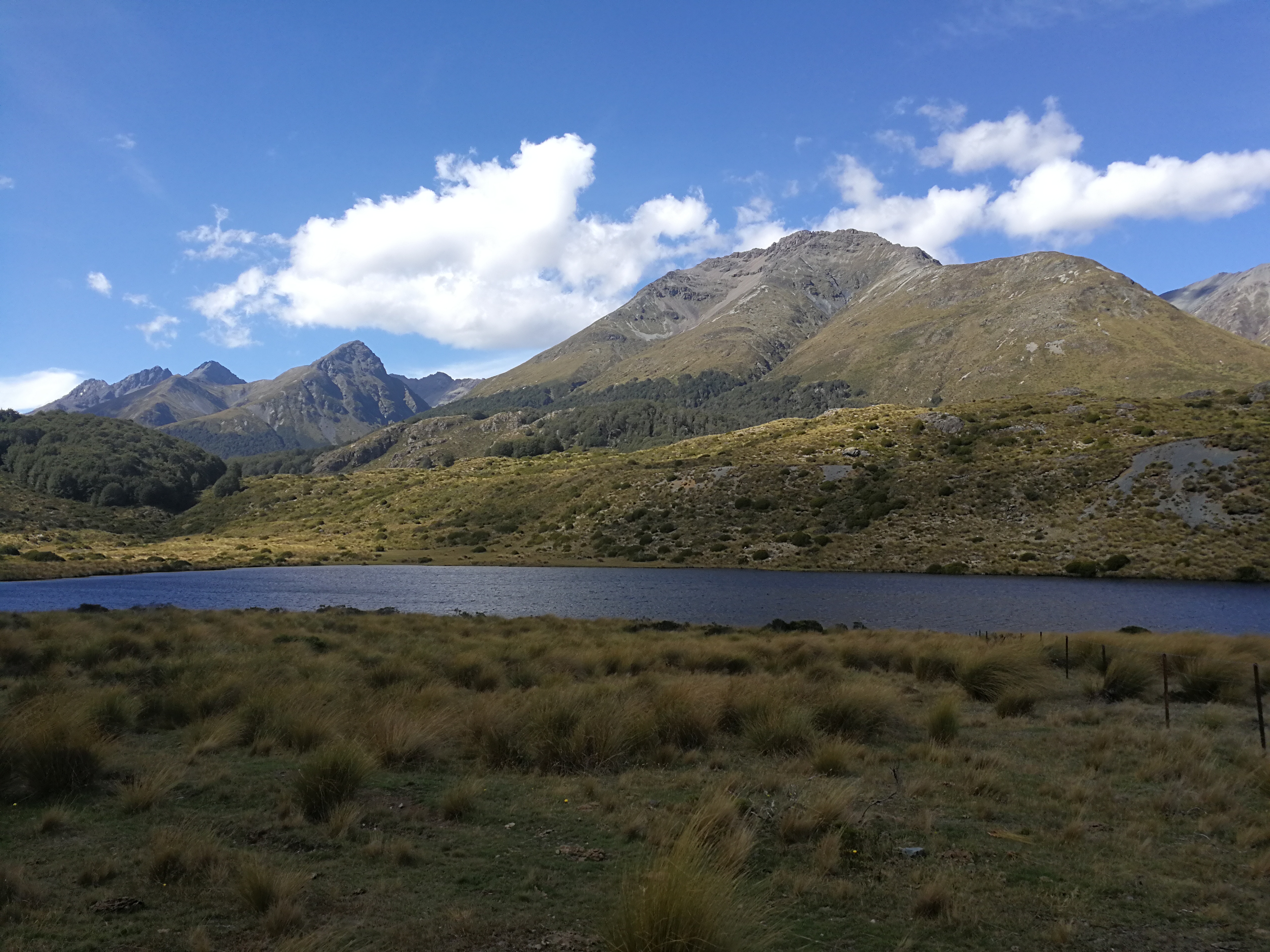
It was another cold morning, definitely feeling like summer is fading. There were clouds on the mountain tops, but they burned off as I walked along the 4WD track along the length of the North Mavora Lake. By the time I got to the campsite at the southern end it was a beautiful day, and warm enough to take my jumper off.

I crossed a swing bridge and entered a beautiful flat and easy woodland path. Coming to the south lake I sat on a little peninsula for a while, as it seemed a shame to get to the hut too early on a day like today.
I caught up with Ali and Liv and we had a long lunch in a mossy glade by the river, enjoying the gorgeous day and path.
The trail undulated in the forest but soon flattened out again, and the wind started to move the treetops. The beech trees grew so tall and thin that it didn’t take much to shake them about.
I reached the junction to the hut and 10 minutes of crossing the river plains later and I arrived at the hut to find Johan chatting with a hunter who was on his way out. It was rutting season soon and he was scoping out where the hinds were.
The girls soon arrived and we lounged in the sun on the veranda of what felt like our private hut. I went down to the river and stripped for a proper wash (read: quick dunk and scrub as I gasped for breath from the cold water).
Jo turned up later with a branch strapped to her forearm, “I might need some help.” She’d fallen over and hurt her wrist – thinking it was sprained but now that it could be fractured as it had swollen a lot. She was a nurse so together with Ali they strapped it up using Jo’s shoe insole which had a hard base.
Day 57: Kiwi Burn Hut to Te Anau
29km, +100m -300m, 7 hours
There was a river crossing first thing so we waited for Jo to be ready to leave to make sure she got across okay with her dodgy ankle and wrist. She then clambered over a fence to go up to the road to hitch to a hospital.
We took the river path, following closely a farm fence to start with. There wasn’t much of a trail, with long grass and tall scrub, on uneven cattle flats, with boggy swamps, dense gorse and bracken with random speargrass thrown in, and I often lost the path. It was rather tedious.
After a couple of hours I checked the map and saw we were close to the road. It was an easy decision to climb up and through a gate onto the gravel road. It made the walk out a bit longer, as it was going to be about 20km of road, but it would be quicker than battling the bog and gorse. We put our music on.

We stopped for lunch after 10 km, the clouds cleared and the temperatures rose. There was little traffic on the gravel road but a few lorries and campervans, which covered us in dust on passing. I had to put sunglasses on to ease the glare of the sun from the white gravel.
Near the end a cycle tourer stopped and asked if I had enough food and water. We chatted for a bit – he had cycled down from Christchurch and was heading back up to Abel Tasman.
We’d made good time on the road and reached the highway by early afternoon. After 20 minutes we got a hitch with Corey, who ended up giving us an hour tour guide trip around Manapouri and Te Anau, stopping a few times to get out and take pictures, then dropping us off at our holiday park. Legend.
We checked into our 3 bed unit, got massive ice creams from reception and crossed the road to eat them by the lake shore. As we were sorting out laundry and going to shower Jo knocked on our door (“I asked at reception for the 3 English girls”). Her arm was in a cast and she was getting the bus to Invercargill to her mum’s in the morning. We met up for dinner later, eating so much I had to waddle back to the park. It was great.
Days 58 and 59: Te Anau
On Friday we became proper tourists and went on a Milford Sound tour – minibus through gorgeous mountains to the sea then a boat trip around the fjords. We were rather lucky with the weather.

The evening and the next day were filled with the usual rest day activities – planning the next section and booking accommodation as needed, eating, resupply, sewing my shoes which fingers crossed should just about make it to Bluff, and more eating. I was reading by the lake when I got my 5th bee sting of the trip – on my neck – and decided that another large ice cream was needed. Medicinal purposes.