April 2018
It’s been a month since I finished the Te Araroa; the scratches, sandfly bites and bruises have faded, my feet look less hobbit-like, and the massive knot in my shoulder is slowly undoing itself.
You can read my day to day activities here, how I got on with gear here, and I wrote a piece for TGO magazine about an overview of the trail here. This post is for some of my thoughts about the TA in general, and some stats.
I took a GoPro with me and filmed bits and pieces as I went, and I’ve stitched them together to make a ‘walk-through’ film of the TA:
Difficulty. The Te Araroa was the hardest walk I’ve done. There’s only so much armchair preparation and mountain training you can do – you can read the trail notes about the river crossings, the sidlings, the scree, the lack of path, but there’s a slight disconnect until you’re actually standing on the scree slope up a mountain 4 days from anywhere – it just doesn’t sink in to the same level.
It was tough physically. Ungraded tracks, steep climbs, long days, heatwaves, strong rivers. It was true what everyone said at the start – that I’d get fitter and it’d get easier – but it was still tough. I’d finish most days pretty tired.
But what surprised me more was how tough emotionally it was. I discovered that 4 days from anywhere is as remote as I need to go. Maybe it was because I got sick too, but that felt wild enough. Knowing that only I could get myself out was hard. Emotions seemed more raw and closer to the surface. But I was grinning to myself every day just walking and marvelling at how I came to be there.
Solitude vs social. I started the walk solo, and even after making friends on the trail most days I would walk by myself and meet up with the others at breaks or at the end of the day. For me this was a perfect mix, as the familiarity of the same people in the evenings contrasted with everything else being new every day. I enjoyed walking alone but got to share highlight moments, and given how remote we often were, it was reassuring to know friends were usually within an hour’s walk.
This was the first long walk I’d done where there was a Facebook group for the year’s cohort of through-hikers, and all the chatter on there, whilst very useful, had me wondering if the trail was going to be super crowded. I needn’t have worried though; the busiest section was in the Richmonds when a storm had caused a backlog of people waiting, but even then it was only a handful.
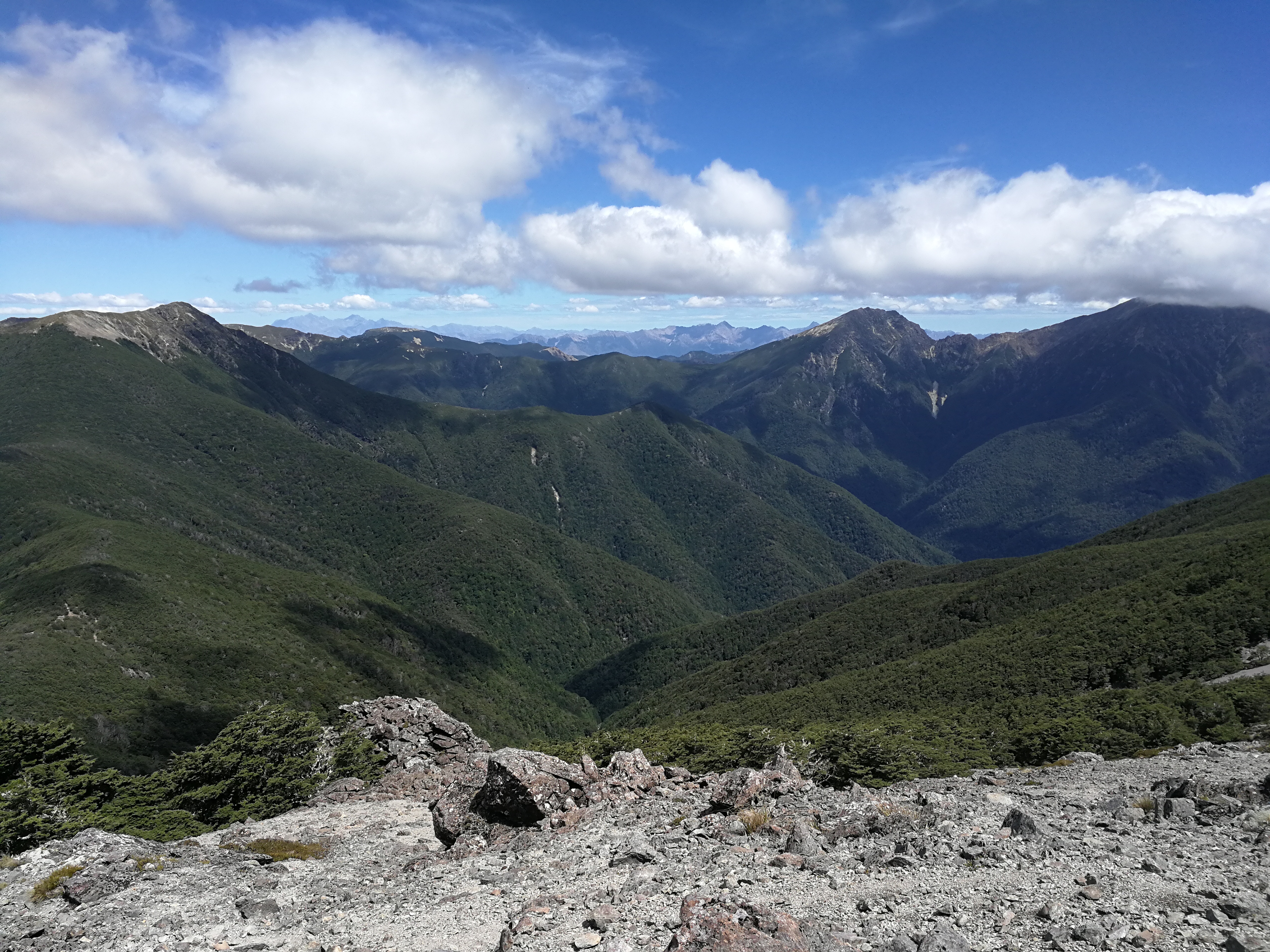
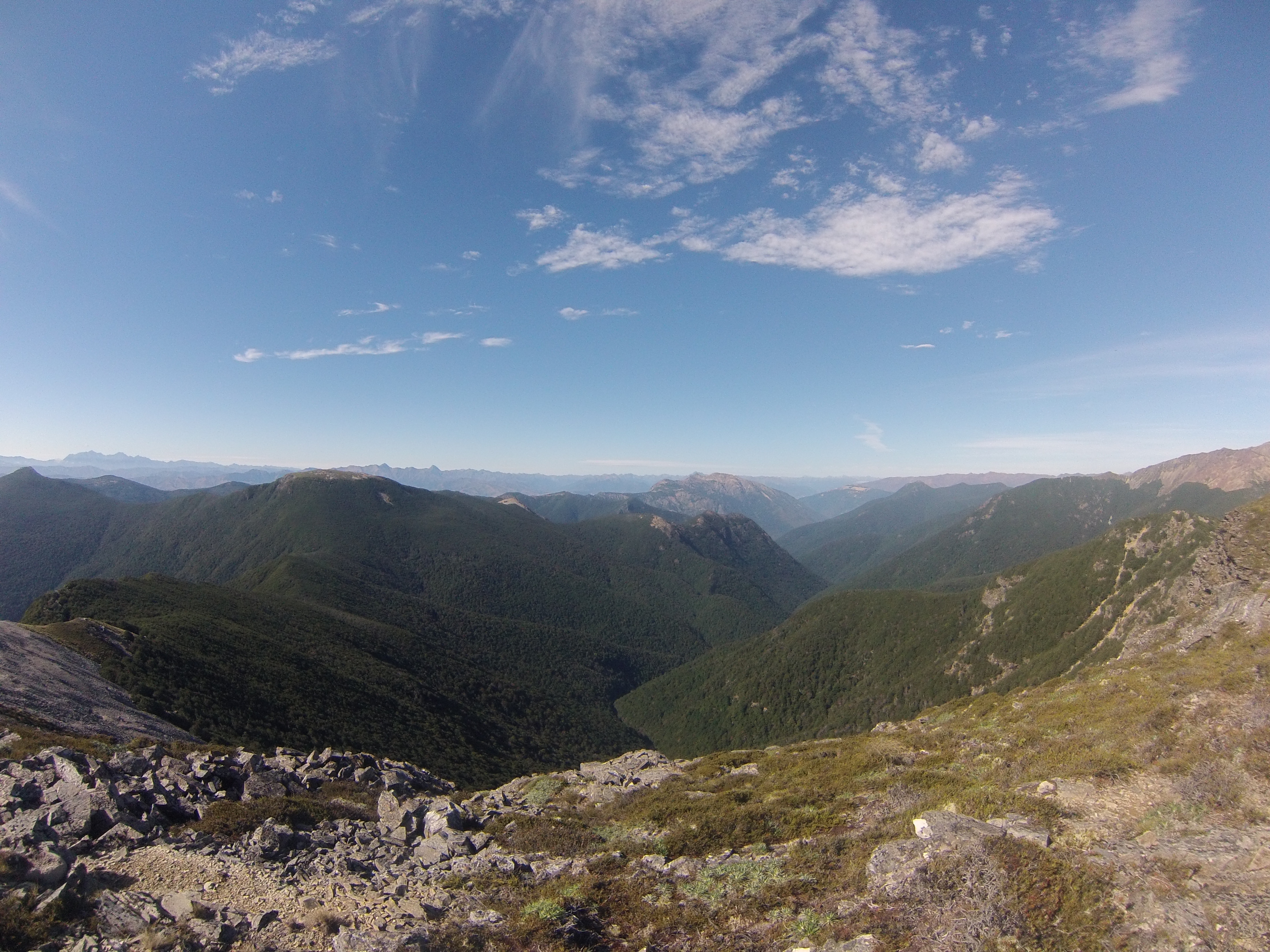
The trail. The trail goes through almost every type of terrain, from temperate rainforest to desert, tussock plains to ancient woodland, farmland to mountains. The type of path varies greatly too. There’s some road walking, though a lot less than in the North Island. Sometimes the path is a 4 wheel drive track, a gravel road, a scree slope, a rockfall field, a sheep track, the roots of beech trees, swamp, a river, or anything in between.
Having wet feet was a fact of near daily life on the TA (regardless of shoe/boot preference), along with the frequent river crossings of various magnitudes. In an unexpected side effect, I now find myself sizing up rivers I see to judge whether I could cross them. We joked whether the TA should have a minimum height restriction as sometimes Ali and Liv, being nearly a foot shorter than me, struggled with the depth or power of a river that I found manageable, which at one point resulted in a 10km detour for them.
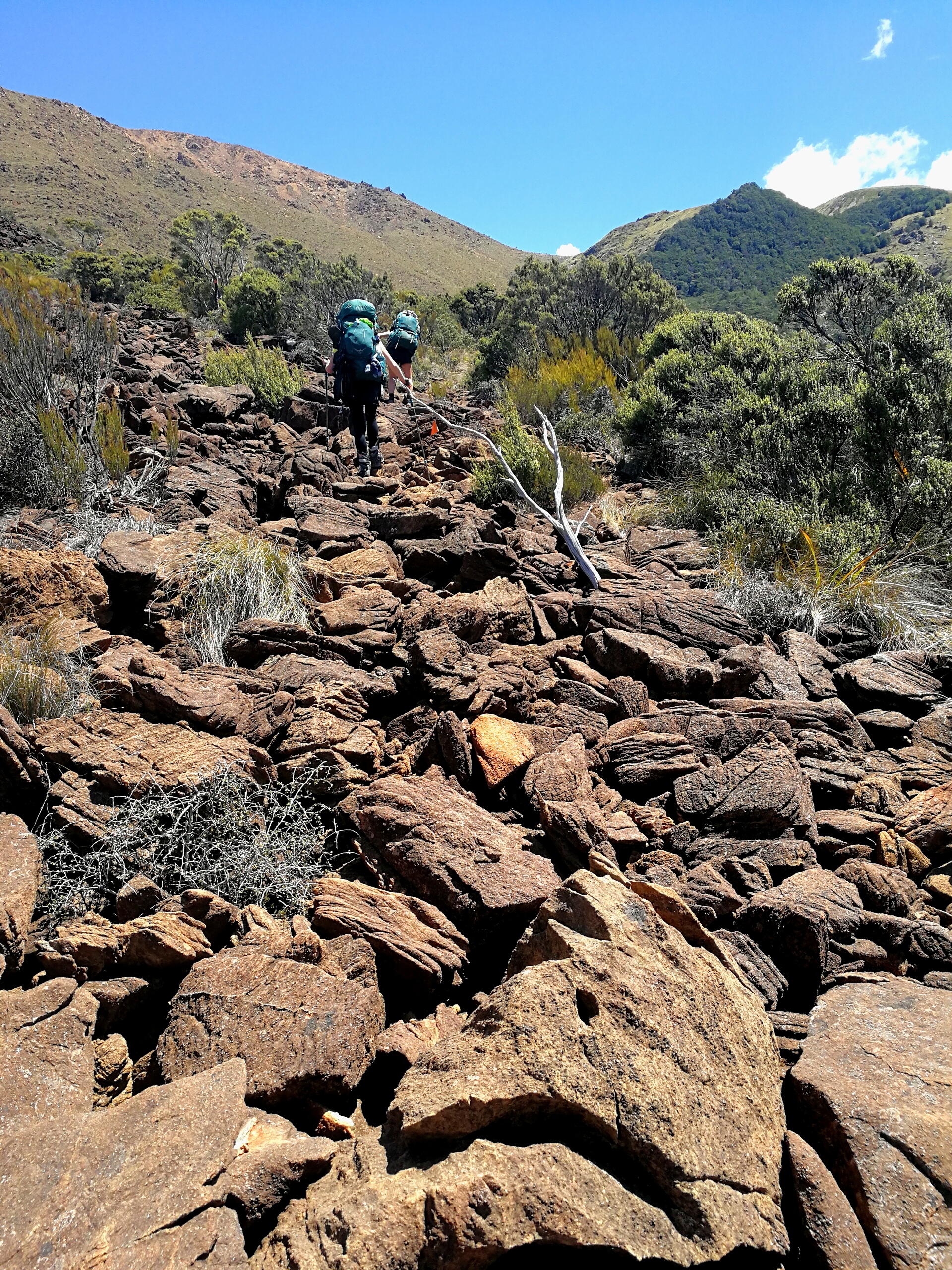
Navigation. In general the trail is well marked. In forest sections in particular, there are frequent orange triangles, and most of the time you can see the next marker before leaving one. In open land the trail is marked by poles topped with orange plastic. Both types of markers can be inconsistent – sometimes on a clear path there’ll be a marker on every other tree, but for the faintest of ground trails there won’t be any in sight. It can be a bit frustrating.
However, this year was the second year of the app ‘Guthook AUS NZ’ having the Te Araroa available. It has both islands, and I bought and downloaded the south island for £25. This has Topo50 maps with the GPX track of the trail (updated each year from the Trust’s GPX) and features marked on the trail with information about them, and the ability for others to leave comments e.g. that on 29th January 2018 there was no water at Red Hills Hut. It also has elevation profiles and readings of distance to features. I probably looked at the app 10 times a day – to see how far up the hill I was, how far away the hut was, how far I’d walked etc.
Weather. On the whole I was remarkably lucky with the weather. NZ had a decent summer – in 2016/17 it had rained most of the time which would have made for a very different experience. There were only 2 days of walking when I had my waterproofs on all day.
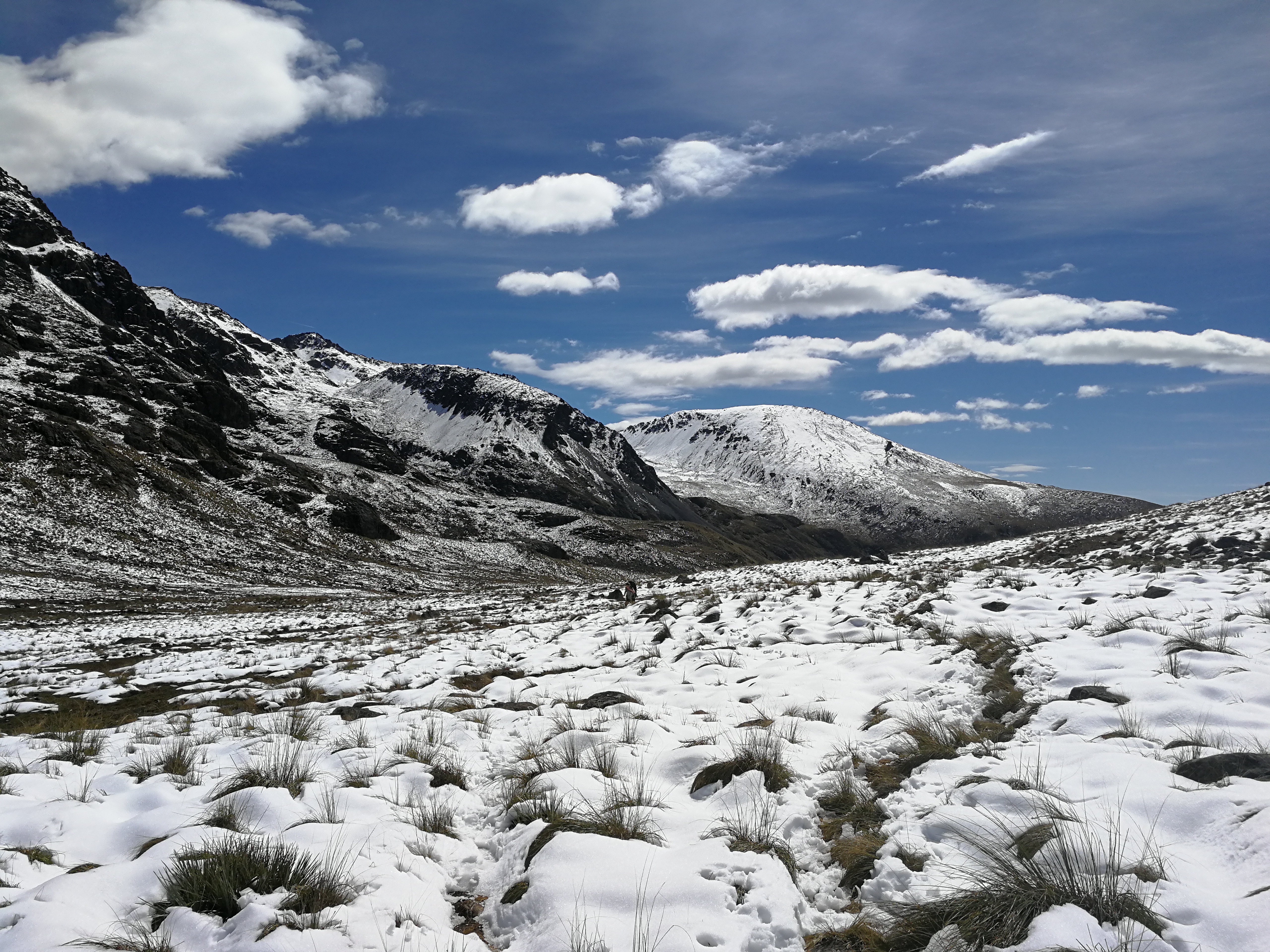
That’s not to say there weren’t challenges. We had to wait out two powerful extra-tropical cyclones which travelled unusually far south to hit the middle of New Zealand. For the first few weeks we were in a heatwave – and I got heatstroke – and later on we were walking through calf deep snow. The UV in New Zealand is strong, and despite putting on factor 50 three times a day sometimes I’d still get burned.
We were lucky and never had to wait out a river in flood in a hut, but it could mean waiting in the huts for a day or two. Reading the hut book was a favourite evening activity and sometimes we’d see comments from people who had been stuck in huts for 3 days to wait for a river to go down.
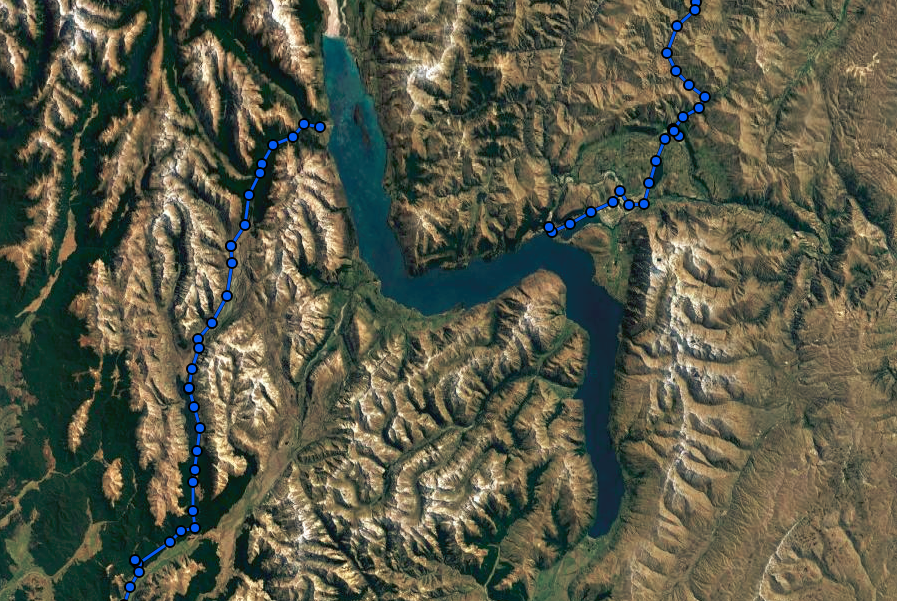
Logistics. The TA isn’t a trail you can just keep walking on forever. There are three natural breaks in the south island around hazard zones – the Rakaia river, the Rangitata river, and the Wakitapu lake at Queenstown.
The two big rivers require some planning as the trail just spits you out in the middle of nowhere. For the first we got a lucky hitch out to Methven – alternatively you can walk to Lake Coleridge, stay at the high-end Lodge and they’ll shuttle you round in the morning. To get back up the south side of the river there’s a 7am school bus from Methven that goes to collect the kids and bring them back out to school (only running during term time and week days) – when my friends took it whilst I was recovering it was apparently a new record, with 17 TA hikers catching it. A few weeks later when the second cyclone hit, it washed out the gravel road and meant the school bus couldn’t go as far up, adding about 20km to the walk.
Getting around the Rangitata, Wayne from Alps2Ocean is the man. At the moment he’s the only one offering shuttles in his mini van, and it’s a hell of walk out and in otherwise (you’d be very lucky to get a hitch). He was doing it by bookings this year but said he thought it might be worth turning up on the north side of the river late afternoon every day next year for a few weeks as the bulk of TAers came through – I think he’d be full most days.
Every year some choose to cross one or both of the rivers, and most survive. It just didn’t seem worth the risk.
There are more options from Queenstown with multiple companies running shuttles around to the trailhead, or some people take their time and hitch round – it would be fairly simple to Glenorchy but the gravel road from there to the trailhead has much lighter traffic.
Weight. I lost about 5kg, expedited initially by heatstroke in the Richmonds meaning I couldn’t eat. Even once my appetite had caught up with the amount of exercise I was doing, it’s very hard to replace the amount of calories you use walking 7 hours a day with a heavy pack over mountains. You just can’t carry enough calories, so we feasted in towns. Even then, some people lost a lot of weight – typically guys as they can’t keep their muscle mass. The girls tended to lose less as they put on muscle.
Future of the TA. When the great American trails of the PCT and AT were developed, long distance hiking wasn’t nearly as big an industry as it is now. The popularity of the trails grew steadily. But the TA was created at a time when many hikers are looking around the world wondering where they can through-hike next, and New Zealand is pretty attractive. As a result the number of TA hikers are growing more rapidly each year than anyone predicted, and than the infrastructure can cope with. The TA was developed linking existing trails rather than deliberately forging new ones, so it makes use of paths and huts that had a different original purpose. This works fine to a point – in the Richmond Ranges, with the huts mostly being 6 or 8 beds, built for hunters, we had people on the floor or camping nearby almost every night. And this was fine, as we had great weather. But we were reading in the hut books about groups of 15 being trapped in 6 bed huts for 3 days because of high rivers. Some of the huts such as Starveal and Slaty are pretty high and exposed – if bad weather came in it would not be a fun place to camp. During our particularly hot spell multiple huts’ rain collection water tanks ran out of water. As more people come through, filling up as they go, this will become more common. Some huts are hours from water sources, so carrying extra water could be needed. I definitely think it will become more of a camping trail, with huts as luxuries rather than the norm.
The kindness of Kiwis is renowned, but is changing already. Some hostels used to offer lifts to the odd hiker up to the trailhead, which of course becomes unsustainable with the increase in numbers. In same cases there are prime opportunities for entrepreneurs to make some cash, such as running shuttles around the Rakaia and Rangitata. A significant portion of the TA trail goes through private land, where the alternative would be a long road walk, so maintaining good relationships with locals is vital.
Then there’s the nature of the trail. People see beautiful instragrammed photos of the TA and choose the through hike as their next, or first backpacking trip. I met some people who hadn’t read the trail notes and didn’t have the TA Trust-provided maps with them. Some of the sections, particularly in the top of the south island, have many warnings about being suitable for experienced trampers only, but people go regardless and then complain how hard/dangerous it was.
Conflicts between TA hikers and Kiwis are also increasing. The Kiwis I met on the trail saw the TA as a positive, bringing more people into the backcountry and boosting local economies. In contrast, I joined a NZ tramping Facebook group to keep up with general backcountry news whilst I was there, and foreign TA hikers were the scapegoat for any negative story, from search and rescue helicopter call-outs to littering or huts being full. I do sympathise to some extent – coming from busy UK areas such as the Lake District I see New Zealand’s mountains as empty, but to locals the increase in walkers relative to a few years ago is substantial in some areas, and there’s the impression of foreigners freeloading on New Zealand’s backcountry. The Department of Conservation (DOC) have no funds to expand huts. Some call for a tourist tax on arrival to the country, or some kind of permit system. As well as the customary voluntary donation to the TA Trust I’d be in favour of a donation/fee to DOC too. The price of the 6 month backcountry hut pass could definitely be increased, perhaps just for foreigners, as at the moment it’s a steal, and for me it worked out at $3 per night in a hut.
I’ll be following the future of the TA with interest!
Some pointless but fun statistics:
1,200km walked
53 days walking
15 zero days
Longest day (time) – Mid Waioria to Hunters Hut, 10.75 hours,
Longest day (distance) – Lower Wairaki to Birchwood Station, 36km
Shortest day (time and distance) – SH73 camp to Arthur’s Pass, 1.5 hours and 5km
Slowest day – Browning Hut to Slaty Hut, 9.5 hours for 14km
Fastest day – Martin’s Hut to Colac Bay, 6 hours for 30km
9 nights in a tent
29 nights in a hut
27 nights in a bed
1,831 photos taken
13GB of film shot
2 full waterproof days
6 days with waterproofs on at some point
37 days with wet feet
Longest time between resupply – 9 days Havelock to St Arnaud
Marvelous, I’ve enjoyed following your posts. A fine achievement.